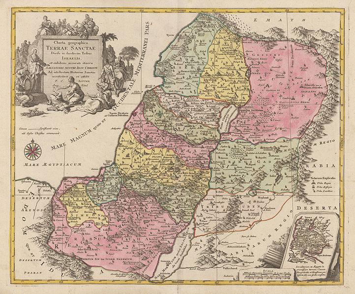
File:Tobias Lotter. Charta geographica Terrae Santae Divisa in duodecim Tribus Israelis.1762.jpg
From Wikimedia Commons, the free media repository
Jump to navigation
Jump to search

Size of this preview: 722 × 599 pixels. Other resolutions: 289 × 240 pixels | 578 × 480 pixels | 925 × 768 pixels | 1,276 × 1,059 pixels.
Original file (1,276 × 1,059 pixels, file size: 777 KB, MIME type: image/jpeg)
File information
Structured data
Captions
Captions
Add a one-line explanation of what this file represents
Summary[edit]
| Tobias Conrad Lotter: Latina: Charta geographica Terrae Santae Divisa in duodecim Tribus Israelis, et exihibens accurate itinera Salvatoris Nostri Iesu Christi. Ad intellectum Historiae Santae accomodavit et edidit T.C. Lotter Aug. Vind.
( |
|||||||||||||||||||||||
|---|---|---|---|---|---|---|---|---|---|---|---|---|---|---|---|---|---|---|---|---|---|---|---|
| Artist |
artist QS:P170,Q106511 |
||||||||||||||||||||||
| Title |
Latina: Charta geographica Terrae Santae Divisa in duodecim Tribus Israelis, et exihibens accurate itinera Salvatoris Nostri Iesu Christi. Ad intellectum Historiae Santae accomodavit et edidit T.C. Lotter Aug. Vind. |
||||||||||||||||||||||
| Description |
English: Copper engraving handcolored in wash and outline, when published. Engraved ca. 1762 by Georg Friedrich Lotter in Augsburg. Decorative map of the Holy Land divided up in its twelve tribes. This detailled map of the Holy Land is ornated in the lower right corner with a small inset map, a well in the upper right corner with a large allegoric decorative title cartouche. |
||||||||||||||||||||||
| Date |
circa 1762 date QS:P571,+1762-00-00T00:00:00Z/9,P1480,Q5727902 |
||||||||||||||||||||||
| Medium | hand-colored | ||||||||||||||||||||||
| Dimensions |
height: 48.8 cm (19.2 in); width: 57.8 cm (22.7 in) dimensions QS:P2048,48.8U174728 dimensions QS:P2049,57.8U174728 |
||||||||||||||||||||||
| Source/Photographer | www.bergbook.com | ||||||||||||||||||||||
| Other versions |
 |
||||||||||||||||||||||
Licensing[edit]
|
This is a faithful photographic reproduction of a two-dimensional, public domain work of art. The work of art itself is in the public domain for the following reason:
The official position taken by the Wikimedia Foundation is that "faithful reproductions of two-dimensional public domain works of art are public domain".
This photographic reproduction is therefore also considered to be in the public domain in the United States. In other jurisdictions, re-use of this content may be restricted; see Reuse of PD-Art photographs for details. | |||||
File history
Click on a date/time to view the file as it appeared at that time.
| Date/Time | Thumbnail | Dimensions | User | Comment | |
|---|---|---|---|---|---|
| current | 10:12, 17 July 2013 |  | 1,276 × 1,059 (777 KB) | Geagea (talk | contribs) | == {{int:filedesc}} == {{Artwork |artist={{Creator:Tobias Lotter}} |title={{la|1=Charta geographica Terrae Santae Divisa in duodecim Tribus Israelis, et exihibens accurate itinera Salvatoris Nostri Iesu Christi. Ad intellectum Historiae Santae accomoda... |
You cannot overwrite this file.
File usage on Commons
The following 2 pages use this file:
File usage on other wikis
The following other wikis use this file:
- Usage on es.wikipedia.org
- Usage on he.wikipedia.org
- Usage on pl.wiktionary.org