File:Tokat districts.png
Here nagîvasyonê
Here lêgerînê
Mezinahiya vê pêşdîtinê: 776 × 600 pîksel. Resolusyonên din: 311 × 240 pîksel | 621 × 480 pîksel | 994 × 768 pîksel | 1056 × 816 pîksel.
Dosyeya orjînal (1056 × 816 pixel, mezinbûnê data: 34 KB, MIME-typ: image/png)
Captions
Captions
Add a one-line explanation of what this file represents
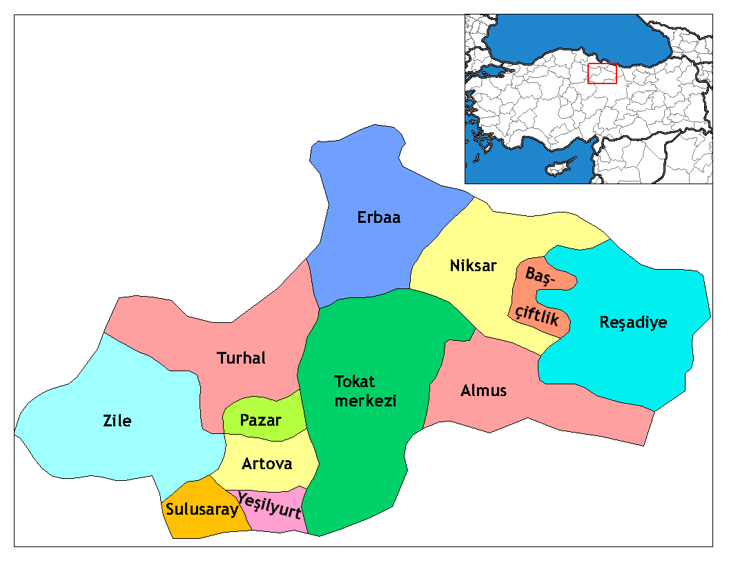
Map of the districts of Tokat province in Turkey
Danasîn
[biguhêre]
| Danasîn | Map of the districts of Tokat province in Turkey. Created by Rarelibra 17:52, 4 December 2006 (UTC) for public domain use, using MapInfo Professional v8.5 and various mapping resources. Edited by One Homo Sapiens Corrected text where İ,Ş,ı,ğ,or ş occurs in name. Source: [statoids-com]. Increased font size and enhanced color differences among adjacent districts. |
| Dîrok | 4 kanûna pêşîn 2006 (original upload date) |
| Çavkanî | No machine-readable source provided. Own work assumed (based on copyright claims). |
| Xwedî | No machine-readable author provided. Rarelibra assumed (based on copyright claims). |
Lîsans
[biguhêre]
| I, the copyright holder of this work, release this work into the public domain. This applies worldwide. In some countries this may not be legally possible; if so: I grant anyone the right to use this work for any purpose, without any conditions, unless such conditions are required by law. |
Dîroka daneyê
Ji bo dîtina guhartoya wê demê bişkoka dîrokê bitikîne.
| Dîrok/Katjimêr | Wêneyê biçûk | Mezinahî | Bikarhêner | Şirove | |
|---|---|---|---|---|---|
| niha | 02:33, 29 kanûna pêşîn 2008 | | 1056 x 816 (34 KB) | One Homo Sapiens (gotûbêj | beşdarî) | Corrected text where İ,Ş,ı,ğ,or ş occurs in name. Source: [statoids-com]. Increased font size and enhanced color differences among adjacent districts. |
| 17:52, 4 kanûna pêşîn 2006 |  | 1056 x 816 (33 KB) | Rarelibra (gotûbêj | beşdarî) | Map of the districts of Tokat province in Turkey. Created by ~~~~ for public domain use, using MapInfo Professional v8.5 and various mapping resources. |
Tu nikarî cardin li ser vê dosyeyê binivîsînî.
Bikaranîna pelê
Ev rûpelên li jêr vê dosyeyê bi kar tînin:
Bikaranîna gerdûnî ya pelê
Ev wîkiyên di rêzê de vê pelê bi kar tînin:
- Bikaranîna di ar.wikipedia.org de
- Bikaranîna di ast.wikipedia.org de
- Bikaranîna di ca.wikipedia.org de
- Bikaranîna di de.wikipedia.org de
- Bikaranîna di diq.wikipedia.org de
- Bikaranîna di en.wikipedia.org de
- Talk:Provinces of Turkey
- Tokat Province
- Yeşilyurt, Tokat
- User talk:Rarelibra/Maps4
- Reşadiye shooting
- List of populated places in Tokat Province
- Districts of Turkey
- Governor of Tokat
- Başçiftlik District
- Tokat District
- Turhal District
- Reşadiye District
- Artova District
- Sulusaray District
- Yeşilyurt District, Tokat
- Zile District
- Almus District
- Erbaa District
- Niksar District
- Pazar District, Tokat
- Bikaranîna di en.wiktionary.org de
- Bikaranîna di eo.wikipedia.org de
- Bikaranîna di es.wikipedia.org de
- Bikaranîna di eu.wikipedia.org de
- Bikaranîna di fa.wikipedia.org de
Zêdetir bikaranîna global a vê pelê bibîne.