File:Topographic map of Åland.svg
跳至導覽
跳至搜尋

此 SVG 檔案的 PNG 預覽的大小:681 × 516 像素。 其他解析度:317 × 240 像素 | 634 × 480 像素 | 1,014 × 768 像素 | 1,280 × 970 像素 | 2,560 × 1,940 像素。
原始檔案 (SVG 檔案,表面大小:681 × 516 像素,檔案大小:172 KB)
說明
說明
添加單行說明來描述出檔案所代表的內容
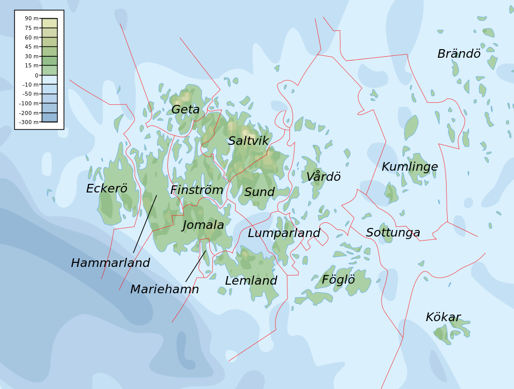
Topographic map of the Åland Islands.
摘要
[編輯]
本vector image使用Inkscape創作 .
| 描述 |
English: Topographic map of the Åland Islands.
Français : Carte topographique des îles d'Åland.
Suomi: Ahvenanmaan topografinen kartta.
Approximate limits:
|
| 日期 | |
| 來源 |
Self-made in Inkscape. Boundaries and municipality borders based on Image:Alandmunicipalities.png. Topography based on public domain GLOBE data from NOAA (http://www.ngdc.noaa.gov/mgg/topo/gltiles.html). Bathymetry adapted after a small slice from T. Seifert, F. Tauber, B. Kayser: 2001: "A high resolution spherical grid topography of the Baltic Sea – 2nd edition", Baltic Sea Science Congress, Stockholm 25-29. November 2001, Poster #147, www.io-warnemuende.de/iowtopo. Colors and overall look based on maps by User:Bamse. |
| 作者 | Mysid |
| 其他版本 | Derivative works of this file: Aland EU.svg |

|
This SVG file contains embedded text that can be translated into your language, using any capable SVG editor, text editor or the SVG Translate tool. For more information see: About translating SVG files. |
授權條款
[編輯]
我,本作品的著作權持有者,決定用以下授權條款發佈本作品:

|
已授權您依據自由軟體基金會發行的無固定段落、封面文字和封底文字GNU自由文件授權條款1.2版或任意後續版本,對本檔進行複製、傳播和/或修改。該協議的副本列在GNU自由文件授權條款中。 |
This file is licensed under the Creative Commons Attribution-Share Alike Attribution-Share Alike 4.0 International, 3.0 Unported, 2.5 Generic, 2.0 Generic and 1.0 Generic license.
- 您可以自由:
- 分享 – 複製、發佈和傳播本作品
- 重新修改 – 創作演繹作品
- 惟需遵照下列條件:
- 姓名標示 – 您必須指名出正確的製作者,和提供授權條款的連結,以及表示是否有對內容上做出變更。您可以用任何合理的方式來行動,但不得以任何方式表明授權條款是對您許可或是由您所使用。
- 相同方式分享 – 如果您利用本素材進行再混合、轉換或創作,您必須基於如同原先的相同或兼容的條款,來分布您的貢獻成品。
您可以選擇您需要的授權條款。
檔案歷史
點選日期/時間以檢視該時間的檔案版本。
| 日期/時間 | 縮圖 | 尺寸 | 使用者 | 備註 | |
|---|---|---|---|---|---|
| 目前 | 2008年2月12日 (二) 11:06 | | 681 × 516(172 KB) | Mysid(留言 | 貢獻) | border wouldn't work |
| 2008年2月12日 (二) 11:05 |  | 681 × 516(172 KB) | Mysid(留言 | 貢獻) | {{inkscape}} {{Information |Description={{en|Topographic map of the Åland Islands.}} {{fi|Ahvenanmaan topografinen kartta.}} |Source=Self-made in Inkscape.<br/>Boundaries and municipality borders based on [[:Imag |
無法覆蓋此檔案。
檔案用途
下列頁面有用到此檔案:
全域檔案使用狀況
以下其他 wiki 使用了這個檔案:
- ar.wikipedia.org 的使用狀況
- az.wiktionary.org 的使用狀況
- ba.wikipedia.org 的使用狀況
- be.wikipedia.org 的使用狀況
- bs.wikipedia.org 的使用狀況
- de.wikipedia.org 的使用狀況
- en.wikipedia.org 的使用狀況
- et.wikipedia.org 的使用狀況
- fi.wikipedia.org 的使用狀況
- fo.wikipedia.org 的使用狀況
- fr.wikipedia.org 的使用狀況
- fy.wikipedia.org 的使用狀況
- gd.wikipedia.org 的使用狀況
- he.wikipedia.org 的使用狀況
- is.wikipedia.org 的使用狀況
- kk.wikipedia.org 的使用狀況
- ky.wikipedia.org 的使用狀況
- lb.wikipedia.org 的使用狀況
- mi.wikipedia.org 的使用狀況
- no.wikipedia.org 的使用狀況
- os.wikipedia.org 的使用狀況
- rue.wikipedia.org 的使用狀況
- ru.wikipedia.org 的使用狀況
- simple.wiktionary.org 的使用狀況
- sl.wikipedia.org 的使用狀況
- sv.wikipedia.org 的使用狀況
- uk.wikipedia.org 的使用狀況
- zh.wikipedia.org 的使用狀況