File:Torino location map winter olympics.PNG
Jump to navigation
Jump to search

Size of this preview: 536 × 599 pixels. Other resolutions: 215 × 240 pixels | 429 × 480 pixels | 687 × 768 pixels.
Original file (687 × 768 pixels, file size: 34 KB, MIME type: image/png)
Captions
Captions
Add a one-line explanation of what this file represents
Summary
[edit]
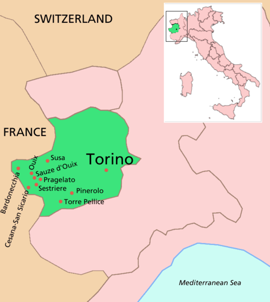
Location map of Torino and other venues and nearby areas for the 2006 Winter Olympics
Locations used in the Olympics near Torino (Turin), with the Province of Turin shown in green. For a blank map, see Image:Torino location map blank.PNG. The inset provinces map is made from combining information from the GNU maps w:Image:Italy Regions Piedmont 220px.png and w:Image:Torino posizione.png.
- Bardonecchia, is the site of the snowboarding competitions. An Olympic Village is also located in Bardonecchia.
- Cesana-San Sicario is the site of biathlon and alpine skiing events.
- Pinerolo, a town of 35,000, located 50 km from Turin, is the host of curling events.
- Pragelato is the site of cross-country skiing, ski jumping, and nordic combined competitions.
- Sauze d'Oulx, a resort located 80 km from Turin, is the host of the freestyle skiing events.
- Sestriere, located 100 km from Turin, is the site of alpine skiing events. An Olympic village is also located in Sestriere.
Licensing
[edit]

|
Permission is granted to copy, distribute and/or modify this document under the terms of the GNU Free Documentation License, Version 1.2 or any later version published by the Free Software Foundation; with no Invariant Sections, no Front-Cover Texts, and no Back-Cover Texts. A copy of the license is included in the section entitled GNU Free Documentation License. |
| This file is licensed under the Creative Commons Attribution-Share Alike 3.0 Unported license. | ||
| ||
| This licensing tag was added to this file as part of the GFDL licensing update. |
File history
Click on a date/time to view the file as it appeared at that time.
| Date/Time | Thumbnail | Dimensions | User | Comment | |
|---|---|---|---|---|---|
| current | 01:00, 21 February 2006 | | 687 × 768 (34 KB) | Roke~commonswiki (talk | contribs) | Location map of Torino and other venues and nearby areas for the 2006 Winter Olympics |
You cannot overwrite this file.
File usage on Commons
There are no pages that use this file.
File usage on other wikis
The following other wikis use this file:
- Usage on ast.wikipedia.org
- Usage on en.wikipedia.org
- Usage on es.wikipedia.org
- Usage on et.wikipedia.org
- Usage on fi.wikipedia.org
- Usage on id.wikipedia.org
- Usage on it.wikipedia.org
- Usage on ko.wikipedia.org
- Usage on lt.wikipedia.org
- Usage on mk.wikipedia.org
- Usage on no.wikipedia.org
- Usage on pl.wikipedia.org
- Usage on pt.wikipedia.org
- Usage on sr.wikipedia.org
- Usage on sv.wikipedia.org
- Usage on tl.wikipedia.org
- Usage on vi.wikipedia.org
- Usage on zh.wikipedia.org