File:Torishima okinawa mlit1978.jpg
Jump to navigation
Jump to search

Size of this preview: 800 × 503 pixels. Other resolutions: 320 × 201 pixels | 640 × 402 pixels | 1,024 × 643 pixels | 1,280 × 804 pixels | 2,432 × 1,528 pixels.
Original file (2,432 × 1,528 pixels, file size: 406 KB, MIME type: image/jpeg)
Captions
Captions
Add a one-line explanation of what this file represents
Summary
[edit]
| Description |
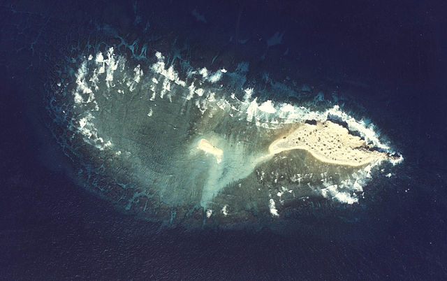
English: Aerial Photograph of Torishima(Kumejima-cho)at Japan (Okinawa) in 1978. The entire island is used as a range for Air force as training.
日本語: 鳥島 (沖縄県 久米島町)の航空写真(1978年)。同じ久米島町内の硫黄鳥島とは別の島。「鳥島射爆撃場」として軍事訓練に利用されている |
| Date | |
| Source | http://w3land.mlit.go.jp/Air/photo400/78/cok-78-1/c2/cok-78-1_c2_2.jpg |
| Author | Tdk |
Licensing
[edit]

|
The copyright holder of this file, the Ministry of Land, Infrastructure, Transport and Tourism of Japan, allows anyone to use it for any purpose, provided that the copyright holder is properly attributed. Redistribution, derivative work, commercial use, and all other use is permitted. |
Attribution:
Copyright © National Land Image Information (Color Aerial Photographs), Ministry of Land, Infrastructure, Transport and Tourism
|
 |
This image is copyrighted by the Ministry of Land, Infrastructure, Transport and Tourism of Japan. For terms of use, see the stipulation to use of National Land Information (in Japanese) and message from MLIT (in Japanese and English). When you display this image on an article, include the following phrase in the description: "Made based on National Land Image Information (Color Aerial Photographs), Ministry of Land, Infrastructure, Transport and Tourism".
|
File history
Click on a date/time to view the file as it appeared at that time.
| Date/Time | Thumbnail | Dimensions | User | Comment | |
|---|---|---|---|---|---|
| current | 04:54, 18 April 2008 | | 2,432 × 1,528 (406 KB) | Tdk~commonswiki (talk | contribs) | {{Information |Description=en:Aerial Photograph of Torishima(Kumejima-cho)at Japan (Okinawa) in 1978. The entire island is used as a range for Air forse s training. ja:鳥島(久米島町)の航空写真(1978年)。同じ久米島町内の硫黄� |
You cannot overwrite this file.
File usage on Commons
There are no pages that use this file.
File usage on other wikis
The following other wikis use this file:
- Usage on cs.wikipedia.org
- Usage on de.wikipedia.org
- Usage on ja.wikipedia.org
- Usage on www.wikidata.org
- Usage on zh-min-nan.wikipedia.org
- Usage on zh.wikipedia.org