File:Tornado Alley.svg
跳转到导航
跳转到搜索

此SVG文件的PNG预览的大小:765 × 600像素。 其他分辨率:306 × 240像素 | 612 × 480像素 | 980 × 768像素 | 1,280 × 1,004像素 | 2,560 × 2,007像素 | 820 × 643像素。
原始文件 (SVG文件,尺寸为820 × 643像素,文件大小:1.26 MB)
说明
说明
添加一行文字以描述该文件所表现的内容
摘要
[编辑]
| 描述 |
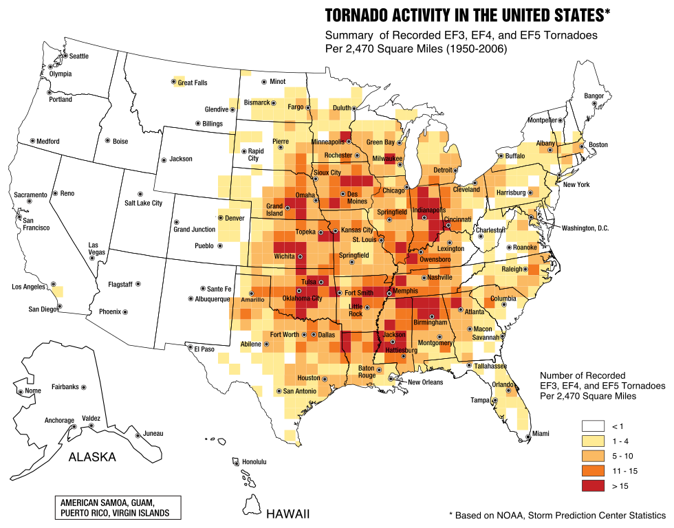
English: A map of the frequency of F3 and greater intensity tornadoes by area. The darker colors highlight the areas typically known as a Tornado Alley. |
| 日期 | |
| 来源 | Image from Federal Emergency Management Agency, a United States government agency, booklet FEMA 320 Third Edition, Section 1, Figure 1.1, page 3, titled Taking Shelter from the Storm: Building a Safe Room Inside your House |
| 作者 | FEMA personnel |
许可协议
[编辑]
|
|
文件历史
点击某个日期/时间查看对应时刻的文件。
| 日期/时间 | 缩略图 | 大小 | 用户 | 备注 | |
|---|---|---|---|---|---|
| 当前 | 2017年5月20日 (六) 23:31 | | 820 × 643(1.26 MB) | Qwewqa(留言 | 贡献) | Rotate and add margins |
| 2017年5月20日 (六) 23:03 |  | 651 × 801(1.24 MB) | Qwewqa(留言 | 贡献) | Fix background | |
| 2017年5月20日 (六) 22:56 |  | 651 × 801(1.28 MB) | Qwewqa(留言 | 贡献) | User created page with UploadWizard |
您不可以覆盖此文件。
文件用途
以下页面使用本文件:
全域文件用途
以下其他wiki使用此文件:
- bg.wikipedia.org上的用途
- br.wikipedia.org上的用途
- el.wikipedia.org上的用途
- en.wikipedia.org上的用途
- he.wikipedia.org上的用途
- th.wikipedia.org上的用途
- zh.wikipedia.org上的用途