File:Tour Solidor DSC 6316-1.JPG
跳至導覽
跳至搜尋

預覽大小:800 × 532 像素。 其他解析度:320 × 213 像素 | 640 × 426 像素 | 1,024 × 681 像素 | 1,280 × 851 像素 | 3,008 × 2,000 像素。
原始檔案 (3,008 × 2,000 像素,檔案大小:1.04 MB,MIME 類型:image/jpeg)
說明
說明
添加單行說明來描述出檔案所代表的內容
摘要
[編輯]
| 描述 |
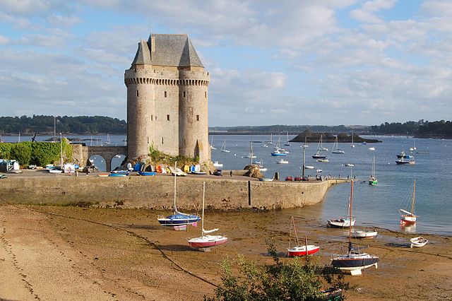
English: The Solidor tower in the estuary of the river Rance in Brittany (France). It was built between 1369 and 1382 by John V, Duke of Brittany (i.e. Jean IV in French) to control access to the Rance at a time when the city of Saint-Malo did not recognize his authority. Over the centuries the tower lost its military interest and became a jail. It is now a museum celebrating Breton sailors exploring Cape Horn. The Solidor tower is located in the former city of Saint-Servan, which merged with Saint-Malo in 1967.
Français : La tour Solidor dans l'estuaire de la Rance près de Saint Malo (Bretagne, France). Ce donjon fut construit entre 1369 et 1382, par le duc Jean IV de Bretagne afin d'avoir un contrôle sur la Rance à une époque où la ville de Saint-Malo était rebelle à son autorité. L'histoire et l'évolution des technologies militaires ayant rendu son usage initial caduc, la tour est transformée en prison pendant la Révolution et l'Empire. Elle héberge depuis 1970 un musée des cap-horniers qui réunit les collections du musée de Saint-Malo sur la navigation au long cours et les cap-horniers (cartes,maquettes,instruments de navigation...). La tour Solidor est située à Saint-Servan, ancienne commune devenue un quartier de la ville de Saint-Malo après une fusion intervenue en 1967. |
| 日期 | |
| 來源 | 自己的作品 |
| 作者 | Pline |
| 拍攝地點 | | 位於此地的本圖片與其他圖片: OpenStreetMap |
|---|
|
This building is indexed in the base Mérimée, a database of architectural heritage maintained by the French Ministry of Culture, under the reference PA00090871
|
授權條款
[編輯]
我,本作品的著作權持有者,決定用以下授權條款發佈本作品:

|
已授權您依據自由軟體基金會發行的無固定段落、封面文字和封底文字GNU自由文件授權條款1.2版或任意後續版本,對本檔進行複製、傳播和/或修改。該協議的副本列在GNU自由文件授權條款中。 |
您可以選擇您需要的授權條款。

|
根據最有價值圖像標準,這張圖像被評定为在Tour Solidor範疇內最有價值的共享資源圖像。你可以在Commons:Valued image candidates/Tour Solidor DSC 6316-1.JPG参看它的提名。 |
檔案歷史
點選日期/時間以檢視該時間的檔案版本。
| 日期/時間 | 縮圖 | 尺寸 | 用戶 | 備註 | |
|---|---|---|---|---|---|
| 目前 | 2008年9月3日 (三) 22:42 | | 3,008 × 2,000(1.04 MB) | Pline(對話 | 貢獻) | {{Information |Description={{en|1=The Solidor tower in the estuary of the river Rance in Brittany (France)}} {{fr|1=La tour Solidor dans l'estuaire de la Rance près de Saint Malo (Bretagne, France)}} |Source=travail personnel (own work) |Author=[[User:Pl |
無法覆蓋此檔案。
檔案用途
下列6個頁面有用到此檔案:
全域檔案使用狀況
以下其他 wiki 使用了這個檔案:
- ceb.wikipedia.org 的使用狀況
- de.wikipedia.org 的使用狀況
- de.wikivoyage.org 的使用狀況
- en.wikipedia.org 的使用狀況
- es.wikipedia.org 的使用狀況
- eu.wikipedia.org 的使用狀況
- fr.wikipedia.org 的使用狀況
- Saint-Malo
- Tour Solidor
- Utilisateur:Pline/Illustrations
- Utilisateur:Pline/photos Saint-Malo
- Liste des monuments historiques de Saint-Malo
- Portail:Duché de Bretagne/Image du jour
- Portail:Duché de Bretagne/Image du jour/12
- Projet:Monuments historiques/Wikidata/liste/35
- Liste des châteaux d'Ille-et-Vilaine
- Liste des musées d'Ille-et-Vilaine
- fr.wikivoyage.org 的使用狀況
- pt.wikipedia.org 的使用狀況
- www.wikidata.org 的使用狀況
- zh.wikipedia.org 的使用狀況