File:Tour Solidor DSC 6316-1.JPG
跳转到导航
跳转到搜索

本预览的尺寸:800 × 532像素。 其他分辨率:320 × 213像素 | 640 × 426像素 | 1,024 × 681像素 | 1,280 × 851像素 | 3,008 × 2,000像素。
原始文件 (3,008 × 2,000像素,文件大小:1.04 MB,MIME类型:image/jpeg)
说明
说明
添加一行文字以描述该文件所表现的内容
摘要
[编辑]
| 描述 |
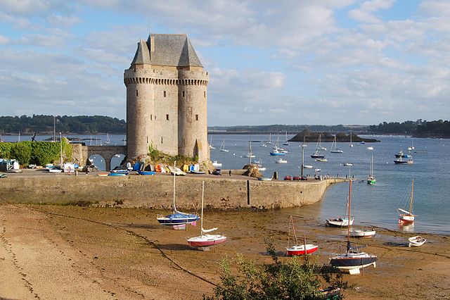
English: The Solidor tower in the estuary of the river Rance in Brittany (France). It was built between 1369 and 1382 by John V, Duke of Brittany (i.e. Jean IV in French) to control access to the Rance at a time when the city of Saint-Malo did not recognize his authority. Over the centuries the tower lost its military interest and became a jail. It is now a museum celebrating Breton sailors exploring Cape Horn. The Solidor tower is located in the former city of Saint-Servan, which merged with Saint-Malo in 1967.
Français : La tour Solidor dans l'estuaire de la Rance près de Saint Malo (Bretagne, France). Ce donjon fut construit entre 1369 et 1382, par le duc Jean IV de Bretagne afin d'avoir un contrôle sur la Rance à une époque où la ville de Saint-Malo était rebelle à son autorité. L'histoire et l'évolution des technologies militaires ayant rendu son usage initial caduc, la tour est transformée en prison pendant la Révolution et l'Empire. Elle héberge depuis 1970 un musée des cap-horniers qui réunit les collections du musée de Saint-Malo sur la navigation au long cours et les cap-horniers (cartes,maquettes,instruments de navigation...). La tour Solidor est située à Saint-Servan, ancienne commune devenue un quartier de la ville de Saint-Malo après une fusion intervenue en 1967. |
| 日期 | |
| 来源 | 自己的作品 |
| 作者 | Pline |
| 相机位置 | | 在以下服务上查看本图像和附近其他图像: OpenStreetMap |
|---|
|
This building is indexed in the base Mérimée, a database of architectural heritage maintained by the French Ministry of Culture, under the reference PA00090871
|
许可协议
[编辑]
我,本作品著作权人,特此采用以下许可协议发表本作品:

|
已授权您依据自由软件基金会发行的无固定段落及封面封底文字(Invariant Sections, Front-Cover Texts, and Back-Cover Texts)的GNU自由文件许可协议1.2版或任意后续版本的条款,复制、传播和/或修改本文件。该协议的副本请见“GNU Free Documentation License”。 |
- 您可以自由地:
- 共享 – 复制、发行并传播本作品
- 修改 – 改编作品
- 惟须遵守下列条件:
- 署名 – 您必须对作品进行署名,提供授权条款的链接,并说明是否对原始内容进行了更改。您可以用任何合理的方式来署名,但不得以任何方式表明许可人认可您或您的使用。
- 相同方式共享 – 如果您再混合、转换或者基于本作品进行创作,您必须以与原先许可协议相同或相兼容的许可协议分发您贡献的作品。
您可以选择您需要的许可协议。

|
根据最有价值图像标准,这张图像被评定为在Tour Solidor范畴内最有价值的共享资源图像。你可以在Commons:Valued image candidates/Tour Solidor DSC 6316-1.JPG参看它的提名。 |
文件历史
点击某个日期/时间查看对应时刻的文件。
| 日期/时间 | 缩略图 | 大小 | 用户 | 备注 | |
|---|---|---|---|---|---|
| 当前 | 2008年9月3日 (三) 22:42 | | 3,008 × 2,000(1.04 MB) | Pline(留言 | 贡献) | {{Information |Description={{en|1=The Solidor tower in the estuary of the river Rance in Brittany (France)}} {{fr|1=La tour Solidor dans l'estuaire de la Rance près de Saint Malo (Bretagne, France)}} |Source=travail personnel (own work) |Author=[[User:Pl |
您不可以覆盖此文件。
文件用途
以下6个页面使用本文件:
全域文件用途
以下其他wiki使用此文件:
- ceb.wikipedia.org上的用途
- de.wikipedia.org上的用途
- de.wikivoyage.org上的用途
- en.wikipedia.org上的用途
- es.wikipedia.org上的用途
- eu.wikipedia.org上的用途
- fr.wikipedia.org上的用途
- Saint-Malo
- Tour Solidor
- Utilisateur:Pline/Illustrations
- Utilisateur:Pline/photos Saint-Malo
- Liste des monuments historiques de Saint-Malo
- Portail:Duché de Bretagne/Image du jour
- Portail:Duché de Bretagne/Image du jour/12
- Projet:Monuments historiques/Wikidata/liste/35
- Liste des châteaux d'Ille-et-Vilaine
- Liste des musées d'Ille-et-Vilaine
- fr.wikivoyage.org上的用途
- pt.wikipedia.org上的用途
- www.wikidata.org上的用途
- zh.wikipedia.org上的用途