File:Towns Bosporan Kingdom.png
Jump to navigation
Jump to search
No higher resolution available.
Towns_Bosporan_Kingdom.png (425 × 349 pixels, file size: 22 KB, MIME type: image/png)
Captions
Captions
Add a one-line explanation of what this file represents
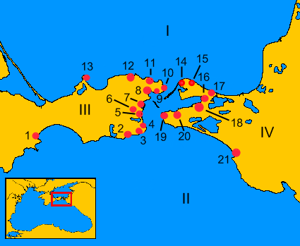
- Description of the map-Opis mapy:
- I)Maeotian Lake (Sea of Azov) – Jezioro Meockie (Morze Azowskie)
- II)Euxine Sea (Black Sea) – Pontus Euxinus (Morze Czarne)
- III)Kerch Peninsula (Crimea) - Półwysep Kerczeński (Krym)
- IV)Taman Peninsula - Półwysep Tamański
- 1)Feodosiya – Teodozja
- 2)Kimmerikon (lat. Cimmericum)
- 3)Kytaia (lat. Cytaea) – Kytaja
- 4)Acra - Akra
- 5)Nymphaion (lat. Nymphaeum) – Nimfajon
- 6)Iluraton
- 7)Tyritake
- 8)Panticapaion (lat. Panticapaeum) – Pantikapajon
- 9)Mirmekion (lat. Myrmecium) – Myrmekjon
- 10)Parthenion (lat. Parthenium) – Partenion
- 11)Porthmion (lat. Porthmeus) - Portmion
- 12)Zenonow Chersonesos - Chersonez Zenonowy
- 13)Heraklion
- 14)Achilion (lat. Achileum)
- 15)Cimmeris - Kimmeris
- 16)Kepoi (lat. Cepi)
- 17)Tyrambe
- 18) Phanagoria – Fanagoria
- 19)Corcondama - Korkondama
- 20)Hermonassa
- 21)Gorgippia
- I)Maeotian Lake (Sea of Azov) – Jezioro Meockie (Morze Azowskie)
| Description |
English: Ancient towns of the south part of Bosporan Kingdom
Español: Las antiguas ciudades del sur del Reino del Bósforo
Polski: Starożytne miasta południowej części Królestwa Bosporańskiego |
||
| Date | 31.10 – 06.11.2007 | ||
| Source | Own work, with help OMC; on the basis of maps from [1] and [2] | ||
| Author | Janmad | ||
| Permission (Reusing this file) |
I, the copyright holder of this work, hereby publish it under the following licenses:
This file is licensed under the Creative Commons Attribution 3.0 Unported license.
You may select the license of your choice. |

File history
Click on a date/time to view the file as it appeared at that time.
| Date/Time | Thumbnail | Dimensions | User | Comment | |
|---|---|---|---|---|---|
| current | 11:06, 7 November 2007 | | 425 × 349 (22 KB) | Janmad (talk | contribs) | new version |
| 10:29, 31 October 2007 |  | 425 × 349 (16 KB) | Janmad (talk | contribs) | *Description of the map-Opis mapy:<br> **I)Maeotian Lake (Sea of Azov) – Jezioro Meockie (Morze Azowskie)<br> **II)Euxine Sea (Black Sea) – Pontus Euxinus (Morze Czarne)<br> **1) Feodosiya – Teodozja<br> **2) Kimmerikon<br> **3)Kition - Kitejon<br> |
You cannot overwrite this file.
File usage on Commons
There are no pages that use this file.
File usage on other wikis
The following other wikis use this file:
- Usage on es.wikipedia.org
- Usage on fi.wikipedia.org
- Usage on hr.wikipedia.org
- Usage on pl.wikipedia.org
- Usage on pl.wiktionary.org
- Usage on ru.wikipedia.org
- Usage on uk.wikipedia.org