File:Toyamako-LineRouteMap1.png
Jump to navigation
Jump to search
No higher resolution available.
Toyamako-LineRouteMap1.png (256 × 480 pixels, file size: 11 KB, MIME type: image/png)
Captions
Captions
Add a one-line explanation of what this file represents
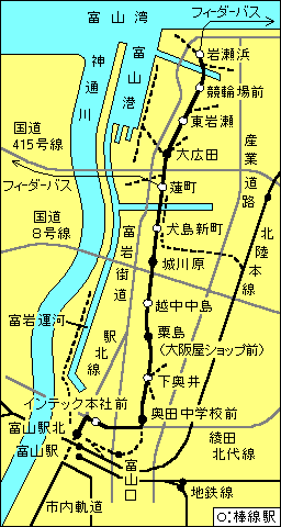
2007年時点の路線図です。投稿者が作成しました。周辺の他路線や一部の道路を含んでいます。地形や線形は、作図の都合から大幅に簡素化しており、方向や位置等が実際とは異なります。太い黒線が現在の路線で、細い黒線が他の路線で、灰色の線は道路です。また黒の破線は、かつての貨物専用線、富山口駅周辺の廃止区間、新幹線完成後に予定されている市内軌道線との接続線です。
図中の他路線については、
地鉄線:富山地方鉄道の本線と不二越線
市内軌道:富山地方鉄道の富山市内軌道線
また、図中の道路については、
富岩街道:県道30号富山港線と県道1号富山魚津線
産業道路:県道172号八幡田稲荷線
駅北線:市道富山駅北線
綾田北代線:市道綾田北代線(あいでんきただいせん)
なお、いたち川、建設中の北陸新幹線は、省略しました。
| This file is licensed under the Creative Commons Attribution-Share Alike 3.0 Unported license. Subject to disclaimers. | ||
| ||
| This licensing tag was added to this file as part of the GFDL licensing update. |

|
Permission is granted to copy, distribute and/or modify this document under the terms of the GNU Free Documentation License, Version 1.2 or any later version published by the Free Software Foundation; with no Invariant Sections, no Front-Cover Texts, and no Back-Cover Texts. A copy of the license is included in the section entitled GNU Free Documentation License. Subject to disclaimers. |
File history
Click on a date/time to view the file as it appeared at that time.
| Date/Time | Thumbnail | Dimensions | User | Comment | |
|---|---|---|---|---|---|
| current | 13:47, 1 July 2007 | | 256 × 480 (11 KB) | GAMEGAWA (talk | contribs) | 2007年時点の路線図です。投稿者が作成しました。周辺の他路線や一部の道路を含んでいます。地形や線形は、作図の都合から大幅に簡素化しており、方向や位置等が実際とは異なります。� |
You cannot overwrite this file.
File usage on Commons
There are no pages that use this file.
File usage on other wikis
The following other wikis use this file:
- Usage on ja.wikipedia.org