File:Tracciato pedemontana veneta.svg
Jump to navigation
Jump to search

Size of this PNG preview of this SVG file: 800 × 503 pixels. Other resolutions: 320 × 201 pixels | 640 × 402 pixels | 1,024 × 644 pixels | 1,280 × 805 pixels | 2,560 × 1,609 pixels | 1,050 × 660 pixels.
Original file (SVG file, nominally 1,050 × 660 pixels, file size: 687 KB)
Captions
Captions
Add a one-line explanation of what this file represents
Summary[edit]
| Description |
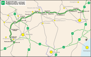
English: Scheme of the Pedemontana Veneta
Italiano: Schema del tracciato della Pedemontana Veneta |
| Date | 11/10/2010 |
| Source | Tracciato Pedemontana Veneta |
| Author | Gigillo83 |
Licensing[edit]
I, the copyright holder of this work, hereby publish it under the following licenses:

|
Permission is granted to copy, distribute and/or modify this document under the terms of the GNU Free Documentation License, Version 1.2 or any later version published by the Free Software Foundation; with no Invariant Sections, no Front-Cover Texts, and no Back-Cover Texts. A copy of the license is included in the section entitled GNU Free Documentation License. |
This file is licensed under the Creative Commons Attribution 3.0 Unported license.
- You are free:
- to share – to copy, distribute and transmit the work
- to remix – to adapt the work
- Under the following conditions:
- attribution – You must give appropriate credit, provide a link to the license, and indicate if changes were made. You may do so in any reasonable manner, but not in any way that suggests the licensor endorses you or your use.
You may select the license of your choice.
File history
Click on a date/time to view the file as it appeared at that time.
| Date/Time | Thumbnail | Dimensions | User | Comment | |
|---|---|---|---|---|---|
| current | 13:27, 11 March 2019 | | 1,050 × 660 (687 KB) | Danielemezzalira (talk | contribs) | sistemazione |
| 14:39, 10 February 2019 |  | 512 × 322 (326 KB) | GiaEsse (talk | contribs) | Cambiato il colore in verde (come da cartelli in loco) e aggiunto il simbolo visto sulla segnaletica | |
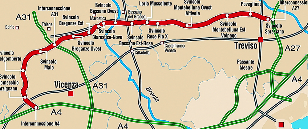
| 11:19, 31 May 2018 |  | 1,050 × 660 (724 KB) | Danielemezzalira (talk | contribs) | Rimozione casello di Breganze Est - non verrà costruito - e ridenominazione di Breganze Ovest in Breganze. Inserimento del lotto 3G - Nuova Castellana. Spostamento ad ovest del casello di Marostica. | |
| 14:27, 7 July 2014 |  | 1,050 × 660 (740 KB) | Danielemezzalira (talk | contribs) | Apertuta Valdastico Sud fino ad Agugliaro | |
| 21:01, 14 October 2012 |  | 1,050 × 660 (740 KB) | Danielemezzalira (talk | contribs) | Completamente rifatto, maggiore dettaglio del tracciato, inserimento principali strade statali (od ex statali) e regionali. | |
| 21:11, 17 October 2010 |  | 1,000 × 500 (469 KB) | Danielemezzalira (talk | contribs) | Piccoli ritocchi | |
| 15:33, 14 October 2010 |  | 1,000 × 500 (471 KB) | Danielemezzalira (talk | contribs) | Spigolosità e posizione Bassano del Grappa e fiume Brenta | |
| 09:49, 13 October 2010 |  | 1,000 × 500 (471 KB) | Gigillo83 (talk | contribs) | Corrections | |
| 21:20, 12 October 2010 |  | 1,000 × 500 (472 KB) | Gigillo83 (talk | contribs) | Corrections | |
| 12:59, 12 October 2010 |  | 1,000 × 470 (500 KB) | Gigillo83 (talk | contribs) | Immagine |
You cannot overwrite this file.
File usage on Commons
There are no pages that use this file.
File usage on other wikis
The following other wikis use this file:
- Usage on de.wikipedia.org
- Usage on fr.wikipedia.org
- Usage on it.wikipedia.org
- Usage on nl.wikipedia.org
- Usage on vec.wikipedia.org