File:Tramway map of Antwerpen.png
Aller à la navigation
Aller à la recherche

Taille de cet aperçu : 800 × 552 pixels. Autres résolutions : 320 × 221 pixels | 640 × 442 pixels | 1 024 × 707 pixels | 1 280 × 884 pixels | 2 560 × 1 767 pixels | 4 511 × 3 114 pixels.
Fichier d’origine (4 511 × 3 114 pixels, taille du fichier : 4,23 Mio, type MIME : image/png)
Légendes
Légendes
Ajoutez en une ligne la description de ce que représente ce fichier
| Description |
|
|||
| Date | ||||
| Source | Travail personnel, using OpenStreetMap data for the background | |||
| Auteur | Maximilian Dörrbecker (Chumwa) | |||
| Autorisation (Réutilisation de ce fichier) |
All OpenStreetMap data and maps are Creative Commons "CC-BY-SA 2.0" licensed Ce fichier est disponible selon les termes de la licence Creative Commons Attribution – Partage dans les Mêmes Conditions 2.0 Générique
|
|||
| Autres versions |
|

.png)
Historique du fichier
Cliquer sur une date et heure pour voir le fichier tel qu'il était à ce moment-là.
| Date et heure | Vignette | Dimensions | Utilisateur | Commentaire | |
|---|---|---|---|---|---|
| actuel | 11 mai 2015 à 06:57 | | 4 511 × 3 114 (4,23 Mio) | Chumwa (d | contributions) | corr |
| 1 mai 2015 à 22:11 |  | 4 511 × 3 114 (3,75 Mio) | Wester (d | contributions) | Borsbek > Borsbeek | |
| 30 avril 2015 à 18:54 |  | 4 511 × 3 114 (4,23 Mio) | Chumwa (d | contributions) | Premetro-Stationen gesondert gekennzeichnet | |
| 30 avril 2015 à 05:01 |  | 4 511 × 3 114 (4,23 Mio) | Chumwa (d | contributions) | Bauvorleistungen für Premetro hinzugefügt | |
| 29 avril 2015 à 05:25 |  | 4 511 × 3 114 (4,15 Mio) | Chumwa (d | contributions) | Umlandgemeinden hinzugefügt | |
| 28 avril 2015 à 20:14 |  | 4 511 × 3 114 (4,07 Mio) | Chumwa (d | contributions) | Stadtgrenze und Distriktgrenzen hinzugefügt | |
| 28 avril 2015 à 05:39 |  | 4 511 × 3 114 (4,19 Mio) | Chumwa (d | contributions) | corr | |
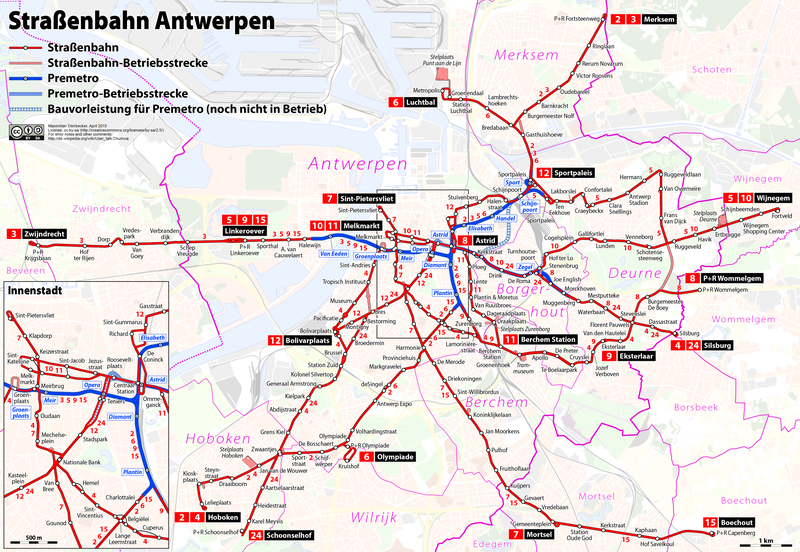
| 28 avril 2015 à 04:57 |  | 4 511 × 3 114 (4,18 Mio) | Chumwa (d | contributions) | {{Information |Description= *{{de|Karte: Netzplan der Straßenbahn Antwerpen}} *{{en|Map of the Antwerp tramway}} *{{fr|Plan du réseau de tramway d'Anvers}} {{Overlay}} |Author=Maximilian Dörrbecker (Chumwa) |... |
Vous ne pouvez pas remplacer ce fichier.
Utilisations locales du fichier
Les 10 pages suivantes utilisent ce fichier :
- User:Chumwa/Gallery
- User:Chumwa/OgreBot/Public transport information/2015 April 21-30
- User:Chumwa/OgreBot/Public transport information/2015 May 1-10
- User:Chumwa/OgreBot/Public transport information/2015 May 11-20
- User:Chumwa/OgreBot/Transport Maps/2015 April 21-30
- User:Chumwa/OgreBot/Transport Maps/2015 May 1-10
- User:Chumwa/OgreBot/Transport Maps/2015 May 11-20
- File:Tramway map of Antwerpen.png
- File:Tramway map of Antwerpen (without background).png
- Category:Trams in Antwerp
Utilisations du fichier sur d’autres wikis
Les autres wikis suivants utilisent ce fichier :
- Utilisation sur de.wikipedia.org
- Utilisation sur eo.wikipedia.org
- Utilisation sur eu.wikipedia.org
- Utilisation sur fr.wikipedia.org
- Utilisation sur hu.wikipedia.org
- Utilisation sur it.wikipedia.org
- Utilisation sur ja.wikipedia.org
- Utilisation sur lv.wikipedia.org
- Utilisation sur nl.wikipedia.org
- Utilisation sur pt.wikipedia.org
- Utilisation sur ro.wikipedia.org
- Utilisation sur ru.wikipedia.org
- Utilisation sur sv.wikipedia.org
- Utilisation sur uk.wikipedia.org
- Utilisation sur www.wikidata.org