File:Triban station.jpg
Jump to navigation
Jump to search

Size of this preview: 800 × 600 pixels. Other resolutions: 320 × 240 pixels | 640 × 480 pixels | 1,024 × 768 pixels | 1,280 × 960 pixels | 2,560 × 1,920 pixels | 3,264 × 2,448 pixels.
Original file (3,264 × 2,448 pixels, file size: 5.18 MB, MIME type: image/jpeg)
Captions
Captions
Add a one-line explanation of what this file represents
Summary
[edit]
| Description |
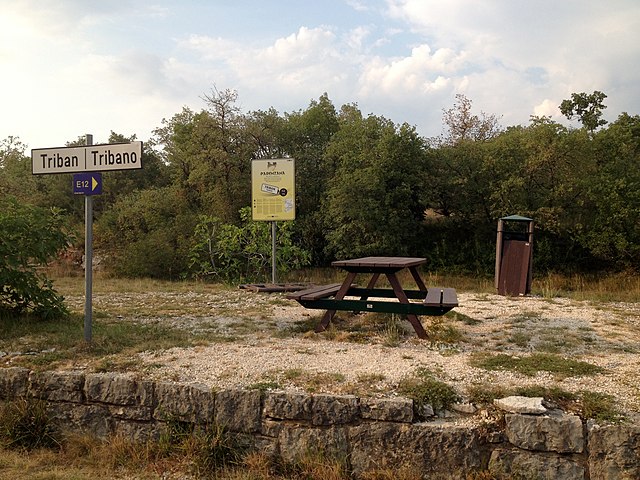
English: former railway station of the Parenzana; now part of the European long-distance path E12 and a mountainbike trail near Buje town
Deutsch: ehemalige Bahnstation der Parenzana; jetzt Teil des Europäischen Fernwanderweges E12 und eine Mountainbikestrecke nahe dem Ort Buje |
| Date | |
| Source | Own work |
| Author | Tommes |
| Camera location | | View this and other nearby images on: OpenStreetMap |
|---|
| Object location | | View this and other nearby images on: OpenStreetMap |
|---|
| This is a retouched picture, which means that it has been digitally altered from its original version. Modifications: Distorsion, Farbe, Kontrast, Beschnitt. Modifications made by Hic et nunc.
|
Licensing
[edit]
I, the copyright holder of this work, hereby publish it under the following license:
This file is licensed under the Creative Commons Attribution-Share Alike 4.0 International license.
- You are free:
- to share – to copy, distribute and transmit the work
- to remix – to adapt the work
- Under the following conditions:
- attribution – You must give appropriate credit, provide a link to the license, and indicate if changes were made. You may do so in any reasonable manner, but not in any way that suggests the licensor endorses you or your use.
- share alike – If you remix, transform, or build upon the material, you must distribute your contributions under the same or compatible license as the original.
This image has been assessed using the Quality image guidelines and is considered a Quality image.
|
File history
Click on a date/time to view the file as it appeared at that time.
| Date/Time | Thumbnail | Dimensions | User | Comment | |
|---|---|---|---|---|---|
| current | 14:45, 28 September 2015 | | 3,264 × 2,448 (5.18 MB) | Tommes (talk | contribs) | == {{int:filedesc}} == {{Information |Description ={{en|1=former railway station of the Parenzana; now part of the European long-distance path E12 and a mountainbike trail near Buje town}} {{de|ehemalige Bahnstat... |
You cannot overwrite this file.
File usage on Commons
The following 4 pages use this file:
File usage on other wikis
The following other wikis use this file:
- Usage on de.wikipedia.org
- Usage on de.wikivoyage.org
- Usage on it.wikipedia.org