File:Trolleybus St Gallen.svg
Jump to navigation
Jump to search

Size of this PNG preview of this SVG file: 800 × 477 pixels. Other resolutions: 320 × 191 pixels | 640 × 382 pixels | 1,024 × 611 pixels | 1,280 × 763 pixels | 2,560 × 1,526 pixels | 3,584 × 2,137 pixels.
Original file (SVG file, nominally 3,584 × 2,137 pixels, file size: 266 KB)
Captions
Captions
Add a one-line explanation of what this file represents
Summary
[edit]| Description |
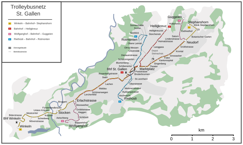
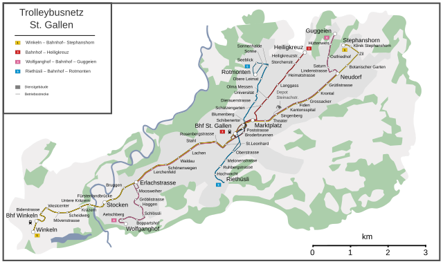
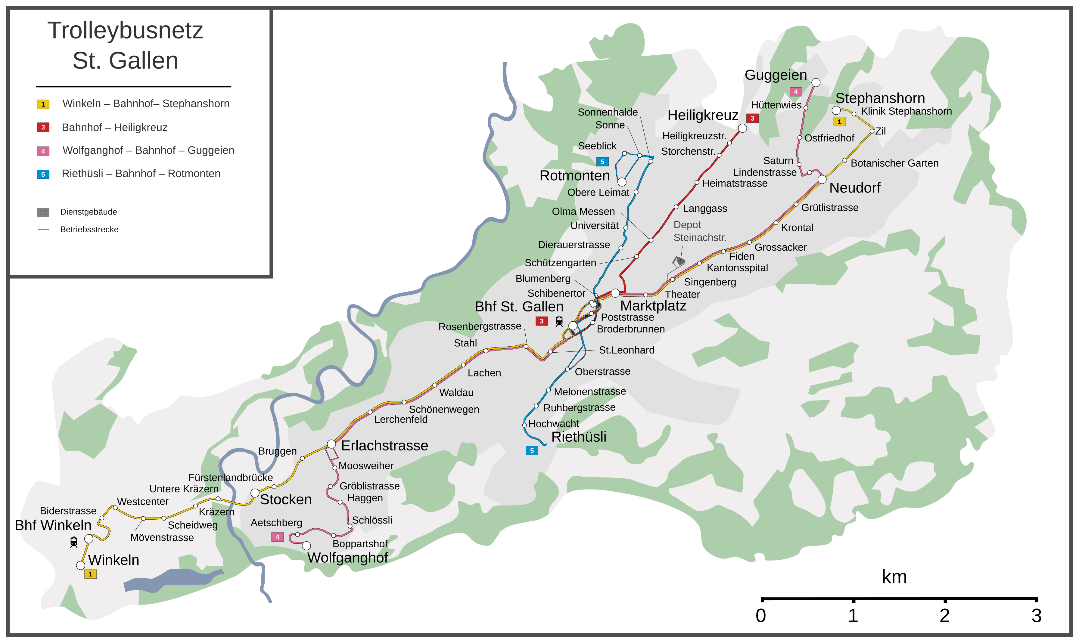
English: Map of the St. Gallen trolleybus system
Deutsch: Karte des Trolleybusnetzes St. Gallen |
| Date | |
| Source |
Own work Map was created using: |
| Author | Pechristener |
| Permission (Reusing this file) |
Map data (c) OpenStreetMap (and) contributors, CC-BY-SA |
| Other versions |
|

Licensing
[edit]
This file is licensed under the Creative Commons Attribution-Share Alike 2.0 Generic license.
- You are free:
- to share – to copy, distribute and transmit the work
- to remix – to adapt the work
- Under the following conditions:
- attribution – You must give appropriate credit, provide a link to the license, and indicate if changes were made. You may do so in any reasonable manner, but not in any way that suggests the licensor endorses you or your use.
- share alike – If you remix, transform, or build upon the material, you must distribute your contributions under the same or compatible license as the original.
File history
Click on a date/time to view the file as it appeared at that time.
| Date/Time | Thumbnail | Dimensions | User | Comment | |
|---|---|---|---|---|---|
| current | 17:15, 3 August 2013 | | 3,584 × 2,137 (266 KB) | Pechristener (talk | contribs) | Version mit grösserer Schrift |
| 22:09, 22 July 2013 |  | 3,584 × 2,137 (266 KB) | Pechristener (talk | contribs) | Finetuning | |
| 22:03, 22 July 2013 |  | 3,584 × 2,137 (270 KB) | Pechristener (talk | contribs) | Detail in der Legende geflickt. | |
| 21:59, 22 July 2013 |  | 3,584 × 2,137 (270 KB) | Pechristener (talk | contribs) | ...der Schriftteufel hat wieder zugeschlagen ... | |
| 21:52, 22 July 2013 |  | 3,584 × 2,137 (275 KB) | Pechristener (talk | contribs) | Verbesserte Version mit mehr Details. | |
| 17:13, 22 July 2013 |  | 3,584 × 2,137 (194 KB) | Pechristener (talk | contribs) | ... die Schrift sollte jetzt auch ohne Serifen sein. | |
| 22:11, 21 July 2013 |  | 3,584 × 2,137 (189 KB) | Pechristener (talk | contribs) | ... noch ein Versuch, den schwarzen Text los zu werden | |
| 22:04, 21 July 2013 |  | 3,584 × 2,137 (187 KB) | Pechristener (talk | contribs) | Problem mit schwarzem Text beseitigt. | |
| 21:56, 21 July 2013 |  | 3,584 × 2,137 (190 KB) | Pechristener (talk | contribs) | == {{int:filedesc}} == {{Information |Description ={{en|1=Map of Trolleybusnetwork in St. Gallen}} {{de|1=Karte des Trolleybusnetzes St. Gallen }} |Source ={{own}} Map was ... |
You cannot overwrite this file.
File usage on Commons
The following 2 pages use this file:
File usage on other wikis
The following other wikis use this file:
- Usage on de.wikipedia.org