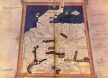
File:Tropaia Drousou.jpg
From Wikimedia Commons, the free media repository
Jump to navigation
Jump to search
Tropaia_Drousou.jpg (625 × 429 pixels, file size: 262 KB, MIME type: image/jpeg)
File information
Structured data
Captions
Captions
Add a one-line explanation of what this file represents
Summary[edit]
| DescriptionTropaia Drousou.jpg |
Deutsch: Der Ortsname "TROPAIA DROUSOU" (hier: trofen), Detailbild von der Karte zur w:de:Germania magna. (Lage von Tropaia Drousou an der Weser, direkt am Nordrand des Melibokon-Gebirges nach den Koordinaten des Ptolemaios) |
||||||||||||||||
| Date | 10. Juni 2014 (upload) | ||||||||||||||||
| Source | |||||||||||||||||
| Author |
creator QS:P170,Q1241997
|
||||||||||||||||
Licensing[edit]
| Public domainPublic domainfalsefalse |
|
The author died in 1490, so this work is in the public domain in its country of origin and other countries and areas where the copyright term is the author's life plus 100 years or fewer. This work is in the public domain in the United States because it was published (or registered with the U.S. Copyright Office) before January 1, 1929. | |
| This file has been identified as being free of known restrictions under copyright law, including all related and neighboring rights. | |
https://creativecommons.org/publicdomain/mark/1.0/PDMCreative Commons Public Domain Mark 1.0falsefalse
File history
Click on a date/time to view the file as it appeared at that time.
| Date/Time | Thumbnail | Dimensions | User | Comment | |
|---|---|---|---|---|---|
| current | 10:51, 10 June 2014 |  | 625 × 429 (262 KB) | Drekamu (talk | contribs) | {{Information |Beschreibung = |Quelle = |Urheber = |Datum = |Genehmigung = |Andere Versionen = |Anmerkungen = }} |
You cannot overwrite this file.
File usage on Commons
There are no pages that use this file.

