File:Tropical Storm Nangka 2003.jpg
跳转到导航
跳转到搜索

本预览的尺寸:465 × 600像素。 其他分辨率:186 × 240像素 | 372 × 480像素 | 595 × 768像素 | 793 × 1,024像素 | 1,587 × 2,048像素 | 6,200 × 8,000像素。
原始文件 (6,200 × 8,000像素,文件大小:9.86 MB,MIME类型:image/jpeg)
说明
说明
添加一行文字以描述该文件所表现的内容
摘要
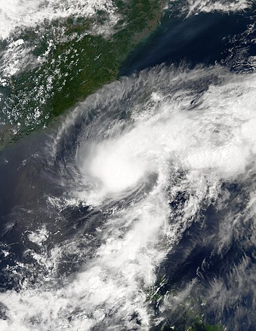
[编辑]| 描述 | This image shows Tropical Storm Nangka on its way to Taiwan on 0530 UTC on June 02, 2003. The storm's maximum sustained wind speeds were at their peak of 50 knots. | |||||
| 日期 | ||||||
| 来源 | http://modis-atmos.gsfc.nasa.gov/IMAGES/MYD02/GRANULE/2003_06_02/153.0530.rgb143.jpg | |||||
| 作者 | Moderate Resolution Imaging Spectroradiometer (MODIS) image from NASA's Aqua satellite | |||||
| 授权 (二次使用本文件) |
|

文件历史
点击某个日期/时间查看对应时刻的文件。
| 日期/时间 | 缩略图 | 大小 | 用户 | 备注 | |
|---|---|---|---|---|---|
| 当前 | 2023年7月31日 (一) 18:55 | | 6,200 × 8,000(9.86 MB) | Sandy14156(留言 | 贡献) | decreased brightness + fixed proportions |
| 2017年12月12日 (二) 03:46 |  | 5,633 × 5,793(2.91 MB) | TheAustinMan(留言 | 贡献) | Higher resolution and grid-less | |
| 2006年9月8日 (五) 21:07 |  | 700 × 700(121 KB) | Good kitty(留言 | 贡献) | == Summary == {{Information |Description=This image shows Tropical Storm Nangka on its way to Taiwan on 0530 UTC on June 02, 2003. The storm's maximum sustained wind speeds were at their peak of 50 knots. |Source=http://modis-atmos.gsfc.nasa.gov/IMAGES/MY |
您不可以覆盖此文件。
文件用途
全域文件用途
以下其他wiki使用此文件:
- en.wikipedia.org上的用途
- ja.wikipedia.org上的用途
- ko.wikipedia.org上的用途
- pt.wikipedia.org上的用途
- th.wikipedia.org上的用途
- vi.wikipedia.org上的用途
- zh.wikipedia.org上的用途