File:Troyville and Baytown cultures map HRoe 2011.jpg
Jump to navigation
Jump to search
No higher resolution available.
Troyville_and_Baytown_cultures_map_HRoe_2011.jpg (600 × 494 pixels, file size: 300 KB, MIME type: image/jpeg)
Captions
Captions
Add a one-line explanation of what this file represents
Summary
[edit]
| Description |
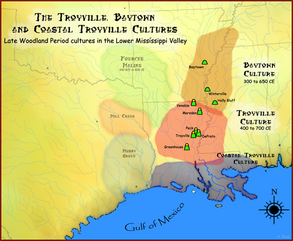
English: A map showing the geographical extent of the Troyville, Coastal Troyville and Baytown cultures during the Late Woodland period in the Southern United States, and some of its important sites. |
| Date | |
| Source | Own work |
| Author | Herb Roe |
Licensing
[edit]
Herb Roe, the copyright holder of this work, hereby publishes it under the following licenses:
This file is licensed under the Creative Commons Attribution-Share Alike 3.0 Unported license.
Attribution: Herb Roe
- You are free:
- to share – to copy, distribute and transmit the work
- to remix – to adapt the work
- Under the following conditions:
- attribution – You must give appropriate credit, provide a link to the license, and indicate if changes were made. You may do so in any reasonable manner, but not in any way that suggests the licensor endorses you or your use.
- share alike – If you remix, transform, or build upon the material, you must distribute your contributions under the same or compatible license as the original.

|
Permission is granted to copy, distribute and/or modify this document under the terms of the GNU Free Documentation License, Version 1.2 or any later version published by the Free Software Foundation; with no Invariant Sections, no Front-Cover Texts, and no Back-Cover Texts. A copy of the license is included in the section entitled GNU Free Documentation License. |
You may select the license of your choice.
File history
Click on a date/time to view the file as it appeared at that time.
| Date/Time | Thumbnail | Dimensions | User | Comment | |
|---|---|---|---|---|---|
| current | 04:50, 24 October 2011 | | 600 × 494 (300 KB) | Heironymous Rowe (talk | contribs) |
You cannot overwrite this file.
File usage on Commons
The following page uses this file:
File usage on other wikis
The following other wikis use this file:
- Usage on ar.wikipedia.org
- Usage on en.wikipedia.org
- Mound Builders
- History of Louisiana
- Holly Bluff site
- Winterville site
- Baytown culture
- User:Heironymous Rowe/Useful books and their citations
- Peck Mounds
- Venable Mound
- Greenhouse site
- DePrato Mounds
- Troyville Earthworks
- Troyville culture
- Marsden Mounds
- Baytown Site
- Mott Archaeological Preserve
- Roland Site
- Template:Baytown and Troyville cultures
- Portal:Louisiana
- Usage on es.wikipedia.org
- Usage on fa.wikipedia.org
- Usage on fr.wikipedia.org
- Usage on sv.wikipedia.org
- Usage on www.wikidata.org