File:Turtle Head Island (Landsat).jpg
Jump to navigation
Jump to search
No higher resolution available.
Turtle_Head_Island_(Landsat).jpg (371 × 371 pixels, file size: 10 KB, MIME type: image/jpeg)
Captions
Captions
Add a one-line explanation of what this file represents
Summary
[edit].jpg&action=edit§ion=1)
| Description |
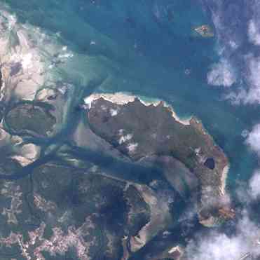
English: Turtle Head Island, middle center, Brewis Island, top right, Trochus Island, middle left. All islands lie in the Newcastle Bay, Queensland, Australia and belong to the Torres Strait Islands. |
| Date | |
| Source |
http://oceancolor.gsfc.nasa.gov/cgi/landsat_extract.pl?path=98&row=68&x=-1382&y=-2560&n=0&t=321 and http://oceancolor.gsfc.nasa.gov/cgi/landsat_extract.pl?path=98&row=68&x=-1382&y=-2330&n=0&t=321 |
| Author | NASA |
Merged two tiles from NASA-Landsat.
Licensing
[edit].jpg&action=edit§ion=2)
| This file is in the public domain in the United States because it was solely created by NASA. NASA copyright policy states that "NASA material is not protected by copyright unless noted". (See Template:PD-USGov, NASA copyright policy page or JPL Image Use Policy.) | ||
 |
Warnings:
|
File history
Click on a date/time to view the file as it appeared at that time.
| Date/Time | Thumbnail | Dimensions | User | Comment | |
|---|---|---|---|---|---|
| current | 12:11, 22 November 2011 | | 371 × 371 (10 KB) | Wurfzoll (talk | contribs) |
You cannot overwrite this file.
File usage on Commons
There are no pages that use this file.
File usage on other wikis
The following other wikis use this file:
- Usage on arz.wikipedia.org
- Usage on ceb.wikipedia.org
- Usage on de.wikipedia.org
- Usage on en.wikipedia.org
- Usage on sv.wikipedia.org
- Usage on www.wikidata.org
.jpg&oldid=520485109)