File:Tutorial optimization shaded relief map 05.jpg
Jump to navigation
Jump to search

Size of this preview: 750 × 600 pixels. Other resolutions: 300 × 240 pixels | 600 × 480 pixels | 960 × 768 pixels | 1,280 × 1,024 pixels.
Original file (1,280 × 1,024 pixels, file size: 133 KB, MIME type: image/jpeg)
Captions
Captions
Add a one-line explanation of what this file represents
Summary
[edit]
| Description |
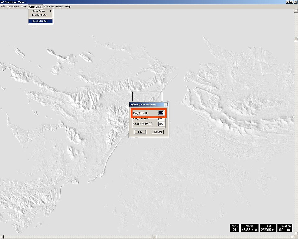
English: Screenshot made for the French speaking Atelier graphique showing a step of a tutorial made to learn how to optimize the shaded relief from a digital elevation model of the Shuttle Radar Topography Mission.
Français : Capture d'écran réalisée dans le cadre de l´Atelier graphique montrant une étape d'un didacticiel destiné à apprendre à optimiser les ombres d'un relief issu de modèles numériques de terrain de la Shuttle Radar Topography Mission ; |
| Date | |
| Source |
English: self-made – software displayed : GIS editor 3DEM from Visualization Software LCC
Français : Réalisation personnelle – logiciel affiché : éditeur SIG 3DEM de Visualization Software LCC ; |
| Author | Eric Gaba (Sting) |
Licensing
[edit]
I, the copyright holder of this work, hereby publish it under the following licenses:

|
Permission is granted to copy, distribute and/or modify this document under the terms of the GNU Free Documentation License, Version 1.2 or any later version published by the Free Software Foundation; with no Invariant Sections, no Front-Cover Texts, and no Back-Cover Texts. A copy of the license is included in the section entitled GNU Free Documentation License. |
| This file is licensed under the Creative Commons Attribution-Share Alike 3.0 Unported license. | ||
| ||
| This licensing tag was added to this file as part of the GFDL licensing update. |
This file is licensed under the Creative Commons Attribution-Share Alike 2.5 Generic, 2.0 Generic and 1.0 Generic license.
- You are free:
- to share – to copy, distribute and transmit the work
- to remix – to adapt the work
- Under the following conditions:
- attribution – You must give appropriate credit, provide a link to the license, and indicate if changes were made. You may do so in any reasonable manner, but not in any way that suggests the licensor endorses you or your use.
- share alike – If you remix, transform, or build upon the material, you must distribute your contributions under the same or compatible license as the original.
You may select the license of your choice.
File history
Click on a date/time to view the file as it appeared at that time.
| Date/Time | Thumbnail | Dimensions | User | Comment | |
|---|---|---|---|---|---|
| current | 20:26, 8 May 2007 | | 1,280 × 1,024 (133 KB) | Sting (talk | contribs) | {{Information |Description= Screenshot made for the French speaking ''Atelier graphique'' showing a step of a tutorial made to learn how to optimize the shaded relief from a digital elevation model of the [[:en:Shuttle |
You cannot overwrite this file.
File usage on Commons
There are no pages that use this file.
File usage on other wikis
The following other wikis use this file:
- Usage on en.wikipedia.org
- Usage on fr.wikipedia.org
- Usage on tg.wikipedia.org