File:Tver-oblast railroads.svg
Jump to navigation
Jump to search

Size of this PNG preview of this SVG file: 750 × 600 pixels. Other resolutions: 300 × 240 pixels | 600 × 480 pixels | 960 × 768 pixels | 1,280 × 1,024 pixels | 2,560 × 2,047 pixels | 1,004 × 803 pixels.
Original file (SVG file, nominally 1,004 × 803 pixels, file size: 339 KB)
Captions
Captions
Add a one-line explanation of what this file represents
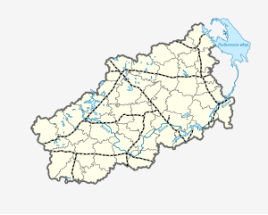
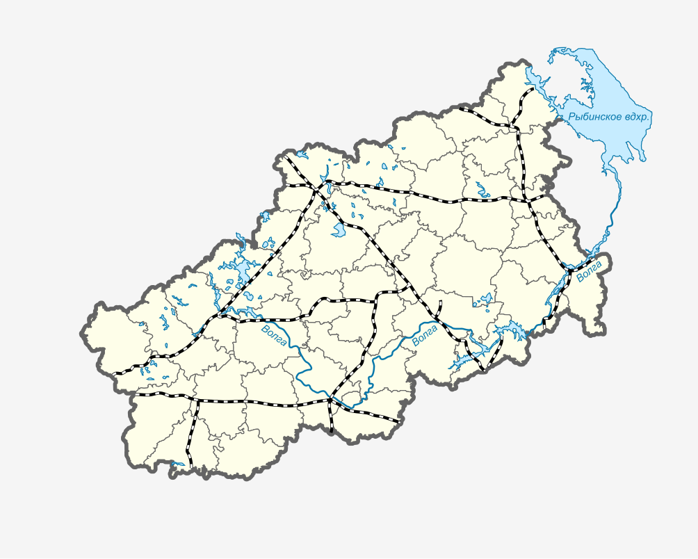
| Description | Locator map of Tver Oblast |
| Date | (UTC) |
| Source | |
| Author |
|
| This is a retouched picture, which means that it has been digitally altered from its original version. Modifications: Delayered. The original can be viewed here: Tver-oblast railroad.svg:
|
I, the copyright holder of this work, hereby publish it under the following licenses:
This file is licensed under the Creative Commons Attribution-Share Alike 2.5 Generic, 2.0 Generic and 1.0 Generic license.
- You are free:
- to share – to copy, distribute and transmit the work
- to remix – to adapt the work
- Under the following conditions:
- attribution – You must give appropriate credit, provide a link to the license, and indicate if changes were made. You may do so in any reasonable manner, but not in any way that suggests the licensor endorses you or your use.
- share alike – If you remix, transform, or build upon the material, you must distribute your contributions under the same or compatible license as the original.

|
Permission is granted to copy, distribute and/or modify this document under the terms of the GNU Free Documentation License, Version 1.2 or any later version published by the Free Software Foundation; with no Invariant Sections, no Front-Cover Texts, and no Back-Cover Texts. A copy of the license is included in the section entitled GNU Free Documentation License. |
| This file is licensed under the Creative Commons Attribution-Share Alike 3.0 Unported license. | ||
| ||
| This licensing tag was added to this file as part of the GFDL licensing update. |
You may select the license of your choice.
Original upload log
[edit]
This image is a derivative work of the following images:
- File:Tver-oblast_railroad.svg licensed with Cc-by-sa-2.5,2.0,1.0, Cc-by-sa-2.5,2.0,1.0, GFDL
- 2009-07-26T20:36:54Z Bandar Lego 1004x803 (428289 Bytes) Subsription added, another small fixes
- 2009-07-17T20:03:21Z Bandar Lego 1004x803 (414063 Bytes) approximated to ortho projection
- 2009-07-13T21:13:56Z Bandar Lego 581x465 (164903 Bytes) all layers
- 2009-07-13T21:12:32Z Bandar Lego 439x345 (80695 Bytes) districts borders outline minimized
- 2009-07-13T21:07:15Z Bandar Lego 581x465 (164903 Bytes) Hydrologic objects
- 2009-07-13T20:13:34Z Bandar Lego 460x363 (103942 Bytes) {{Information |Description=Locator map of Tver Oblast |Source=*[[:File:Tver-oblast.svg|]] |Date=2009-07-13 20:10 (UTC) |Author=*[[:File:Tver-oblast.svg|]]: *[[:File:Tver-oblast.png|Tver-oblast.png]]: [[User:Obersachse|Obersac
Uploaded with derivativeFX
File history
Click on a date/time to view the file as it appeared at that time.
| Date/Time | Thumbnail | Dimensions | User | Comment | |
|---|---|---|---|---|---|
| current | 20:24, 14 August 2009 | | 1,004 × 803 (339 KB) | Bandar Lego (talk | contribs) | {{Information |Description=Locator map of Tver Oblast |Source=*File:Tver-oblast_railroad.svg |Date=2009-08-14 20:24 (UTC) |Author=*File:Tver-oblast_railroad.svg: *Tver-oblast.svg: *[[:File:Tver-oblast.png|Tver-oblast. |
You cannot overwrite this file.
File usage on Commons
The following 3 pages use this file:
File usage on other wikis
The following other wikis use this file:
- Usage on hu.wikipedia.org
- Usage on pl.wikipedia.org
- Rżew-Bałtycki
- Sonkowo (stacja kolejowa)
- Moduł:Mapa/dane/obwód twerski
- Moduł:Mapa/dane/RU-TVE
- Twer (stacja kolejowa)
- Rusanowo (stacja kolejowa)
- Staraja Toropa (stacja kolejowa)
- Barsowo (mijanka)
- 390 km (obwód twerski)
- Ulin (mijanka)
- Zapadnaja Dwina (stacja kolejowa)
- 375 km (obwód twerski)
- Zamoszje (mijanka)
- Ziemcy (stacja kolejowa)
- 354 km (rejon nielidowski)
- 8 km (obwód twerski)
- Podsosienka (mijanka)
- Nielidowo (stacja kolejowa)
- Panikla (stacja kolejowa)
- 10 km (rejon nielidowski)
- Otkos (przystanek kolejowy)
- Kaszczonki (przystanek kolejowy)
- Żarkowskij (stacja kolejowa)
- Mostowaja (stacja kolejowa)
- Ilmanowka (mijanka)
- Olenino (stacja kolejowa)
- Machierowo (stacja kolejowa)
- 273 km (rejon oleniński)
- Łoszaki (przystanek kolejowy)
- Czertolino (stacja kolejowa)
- Monczałowo (stacja kolejowa)
- Murawjowo (mijanka)
- Rżewskij miemoriał
- 239 km (obwód twerski)
- Mielichowo (mijanka)
- 147 km (obwód twerski)
- Rożdiestwieno (mijanka)
- Rżew Białoruski
- 156 km (obwód twerski)
- Osuga (stacja kolejowa)
- 168 km (obwód twerski)
- Aristowo (stacja kolejowa)
- Zubcow (stacja kolejowa)
- Bartieniewo (mijanka)
- 208 km (obwód twerski)
- Kurkowo (mijanka)
- Pogoriełoje Gorodiszcze (stacja kolejowa)
- 188 km (obwód twerski)
- Obowrażje (mijanka)
View more global usage of this file.