File:Two 1911-08-12 weather map.jpg
跳转到导航
跳转到搜索
没有更高的分辨率。
Two_1911-08-12_weather_map.jpg (417 × 305像素,文件大小:24 KB,MIME类型:image/jpeg)
说明
说明
添加一行文字以描述该文件所表现的内容
摘要
| 描述 | ||||
| 日期 | ||||
| 来源 | NOAA Central Library Data Imaging Project | |||
| 作者 | NOAA Central Library, Silver Spring, Maryland | |||
| 授权 (二次使用本文件) |
|
文件历史
点击某个日期/时间查看对应时刻的文件。
| 日期/时间 | 缩略图 | 大小 | 用户 | 备注 | |
|---|---|---|---|---|---|
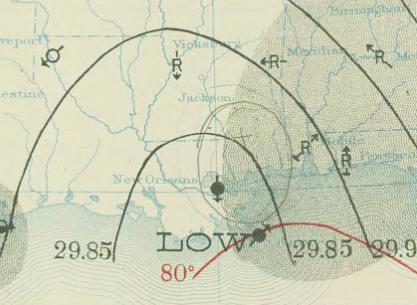
| 当前 | 2010年4月29日 (四) 19:50 | | 417 × 305(24 KB) | Juliancolton(留言 | 贡献) | {{Information |Description={{en|1=August 12, 1911 {{w|surface weather analysis}} of Hurricane Two in the {{w|1910 Atlantic hurricane season}} along the U.S. Gulf Coast. }} |Source=http://docs.lib.noaa.gov/rescue/dwm/1911/19110812.djvu |Author=[http://docs |
您不可以覆盖此文件。
文件用途
以下页面使用本文件:
全域文件用途
以下其他wiki使用此文件:
- ca.wikipedia.org上的用途
- en.wikipedia.org上的用途
- nl.wikipedia.org上的用途
- pt.wikipedia.org上的用途
- zh.wikipedia.org上的用途