File:Txu-oclc-224300691-se19-6.jpg
Ir a la navegación
Ir a la búsqueda

Kay ñawpaq qhawariypa chhikan kaynin: 788 × 600 iñu. Huk huyakukuna: 316 × 240 iñu | 631 × 480 iñu | 1010 × 768 iñu | 1280 × 974 iñu | 2560 × 1948 iñu | 5164 × 3929 iñu.
Qallariy willañiqi (5164 × 3929 iñu; willañiqip chhikan kaynin: 10,27 MB; MIME laya: image/jpeg)
Leyendas
Leyendas
Añade una explicación corta acerca de lo que representa este archivo
Pisichay[llamk'apuy]
| T'iktuna |
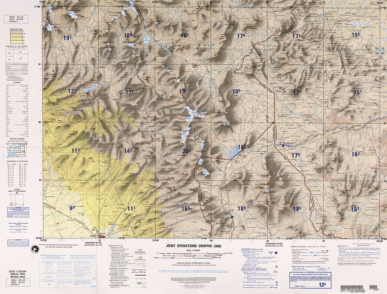
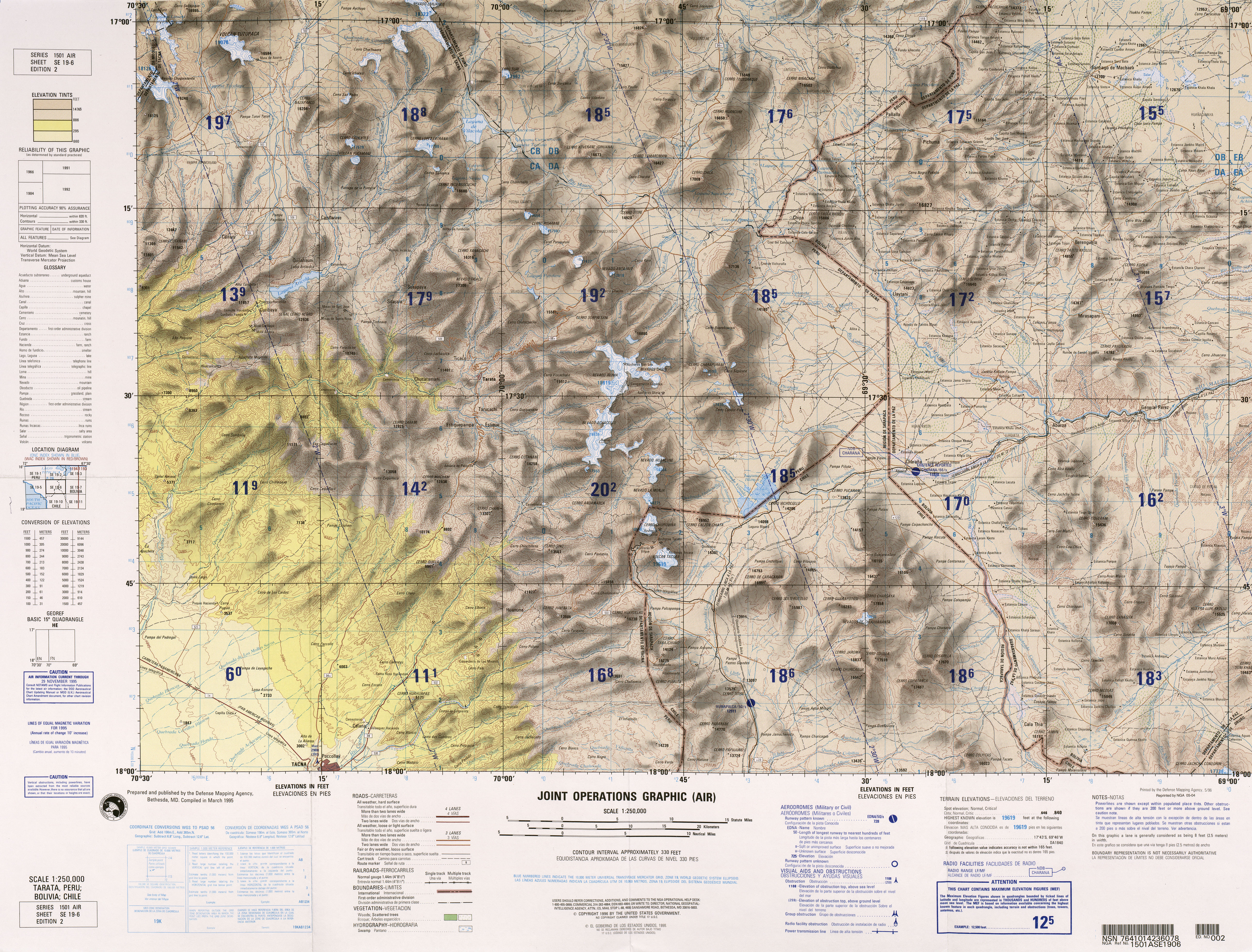
English: frontera Chile-Peru-Bolivia, Tacna |
|||
| P'unchaw | ||||
| Pukyu | http://www.lib.utexas.edu/maps/jog/latin_america/txu-oclc-224300691-se19-6.jpg | |||
| Ruraq | This work is in the public domain in the United States because it is a work of the United States Federal Government under the terms of 17 U.S.C. § 105. See Copyright. | |||
| Saqillay (Kay willañiqita musuqmanta llamk'achiy) |
|
|||
| Huk musuqchasqakuna | Obras derivadas de ésta: Río-cosapilla.png |

.jpg)
Willañiqip wiñay kawsaynin
P'unchaw/pacha nisqapi ñit'iy chaypacha willañiqi kachkasqata qhawanaykipaq.
| P'unchaw/Pacha | Uchuylla rikchacha | Chhikanyachikuqkuna | Ruraq | Willapuy | |
|---|---|---|---|---|---|
| kunan | 23:03 30 dis 2011 | | 5164 × 3929 (10,27 MB) | Keysanger (rimanakuy | llamk'apusqakuna) |
Manam atinkichu kay willañiqita huknachayta.
Maypim willañiqita llamk'achinku
Kay rikchamanqa kay qatiq 3 p'anqakunam t'inkimun:
Mayqin wikikunapi willañiqita llamk'achinku
Kay wakin wikikunam willañiqitaqa llamk'achinku:
- arz.wikipedia.org-pi kaykunapi llamk'achinku
- ca.wikipedia.org-pi kaykunapi llamk'achinku
- ceb.wikipedia.org-pi kaykunapi llamk'achinku
- de.wikipedia.org-pi kaykunapi llamk'achinku
- en.wikipedia.org-pi kaykunapi llamk'achinku
- es.wikipedia.org-pi kaykunapi llamk'achinku
- ka.wikipedia.org-pi kaykunapi llamk'achinku
- pt.wikipedia.org-pi kaykunapi llamk'achinku
- qu.wikipedia.org-pi kaykunapi llamk'achinku
- www.wikidata.org-pi kaykunapi llamk'achinku
- zh.wikipedia.org-pi kaykunapi llamk'achinku
Metadata
Katiguriyakuna:
- Joint Operations Graphic Chile
- Joint Operations Graphic Peru
- Joint Operations Graphic Bolivia
- Maps of Arica and Parinacota Region
- Topographic maps of Bolivia
- Maps of La Paz Department, Bolivia
- Topographic maps of Peru
- Maps of the Puno Region
- Maps of the Tacna Region
- Maps of borders of Bolivia
- Old maps of Bolivia
- Tacora (volcano)
- Yucamane
- Maps of volcanoes in Chile
- Maps of volcanoes in Bolivia
- Tutupaca (volcano)
- Maps of volcanoes in Peru
- Nevados Casiri
- Huancune volcano
- Chupiquiña (volcano)
- Cordillera del Barroso