File:Txu-oclc-6557994-index-457.jpg
跳转到导航
跳转到搜索

本预览的尺寸:791 × 599像素。 其他分辨率:317 × 240像素 | 634 × 480像素 | 1,014 × 768像素 | 1,280 × 970像素 | 2,560 × 1,939像素 | 5,000 × 3,788像素。
原始文件 (5,000 × 3,788像素,文件大小:4.1 MB,MIME类型:image/jpeg)
说明
说明
添加一行文字以描述该文件所表现的内容
摘要[编辑]
| 描述 |
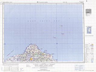
English: Map of the Taipei (T’ai-pei Shih, Taihoku) area of Taiwan, from the Tawian AMS Topographic Maps series |
| 日期 | |
| 来源 | Courtesy of the University of Texas Libraries, The University of Texas at Austin. ([1]) |
| 作者 | Army Map Service (AM), Corps of Engineers, 1950 |
| 其他版本 |
|

-
 Index Map

![[1]](http://legacy.lib.utexas.edu/maps/ams/taiwan/txu-oclc-6557994-ng51-10-450.jpg)
许可协议[编辑]
This image or file is a work of a U.S. Army Corps of Engineers soldier or employee, taken or made as part of that person's official duties. As a work of the U.S. federal government, the image is in the public domain.
|
文件历史
点击某个日期/时间查看对应时刻的文件。
| 日期/时间 | 缩略图 | 大小 | 用户 | 备注 | |
|---|---|---|---|---|---|
| 当前 | 2019年9月13日 (五) 07:18 | | 5,000 × 3,788(4.1 MB) | Geographyinitiative(留言 | 贡献) | User created page with UploadWizard |
您不可以覆盖此文件。
文件用途
以下页面使用本文件:
全域文件用途
以下其他wiki使用此文件:
- de.wikipedia.org上的用途
- en.wikipedia.org上的用途
- Keelung
- Songshan District, Taipei
- Shilin District
- Sanchong District
- Shenkeng District
- Gongliao District
- Ruifang District
- Shuangxi District
- Shimen District
- Bali District
- Keelung Islet
- Tamsui District
- Xizhi District
- Banqiao District
- Xinzhuang District
- Pengjia Islet
- Zhongzheng District, Keelung
- Qidu District
- Zhongshan District, Keelung
- Anle District
- Nuannuan District
- Cape Fugui
- Mianhua Islet
- Huaping Islet
- en.wiktionary.org上的用途
- es.wikipedia.org上的用途
- hy.wikipedia.org上的用途
- it.wikipedia.org上的用途
- ja.wikipedia.org上的用途
- th.wikipedia.org上的用途
- zh.wikipedia.org上的用途