File:Tyndall 1896 Figure 7-MJ.jpg
Jump to navigation
Jump to search

Size of this preview: 393 × 599 pixels. Other resolutions: 157 × 240 pixels | 315 × 480 pixels | 503 × 768 pixels | 671 × 1,024 pixels | 2,088 × 3,184 pixels.
Original file (2,088 × 3,184 pixels, file size: 3.39 MB, MIME type: image/jpeg)
Captions
Captions
Add a one-line explanation of what this file represents
| Description |
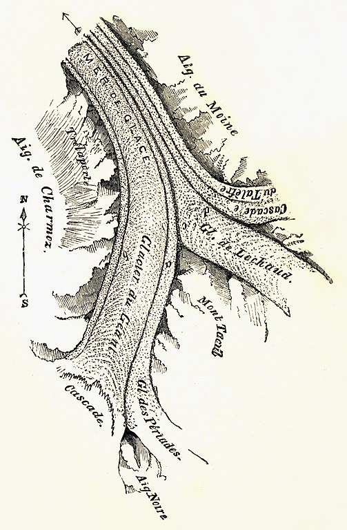
English: Mer de Glace sketchmap by John Tyndall, 1857. Published in The glaciers of the Alps, being a narrative of excursions and ascents, an account of the origin and phenomena of glaciers, and an exposition of the physical principles to which they are related, with illustrations. 2nd edition 1896, Longmans, Green, And Co., London, New York, Bombay.
Fig. 7, page 53. Aiguille Noire to the south dividing the Cascade at the west from Glacier des Périades which flows north to join Glacier du Géant flowing south to north between Mont Tacul on the east and Aiguilles de Charmoz to the west (alongside morraine 'b'). This forms the medial morraine 'a'. Some 3 kilometres downstream, Glacier de Lechaud joins du Géant, forming medial morraine 'c'. Just prior to this confluence, Cascade du Talèfre, with its own medial morraine 'e', joins Lechaud forming morraine 'd'. Here the glacier is known as the Mer De Glace and flows north-north-west between Aiguille du Moine on the east and Trélaporte on the west. |
||||
| Date | |||||
| Source | https://archive.org/details/glaciersalpsbeing00tyndrich | ||||
| Author | John Tyndall (1820-1893) | ||||
| Permission (Reusing this file) |
|
||||
File history
Click on a date/time to view the file as it appeared at that time.
| Date/Time | Thumbnail | Dimensions | User | Comment | |
|---|---|---|---|---|---|
| current | 18:28, 22 March 2010 | | 2,088 × 3,184 (3.39 MB) | DrJunge (talk | contribs) | {{Information |Description={{en|Mer de Glace sketchmap by John Tyndall, 1857. Published in ''The glaciers of the Alps'', being a narrative of excursions and ascents, an account of the origin and phenomena of glaciers, and an exposition of the physical pri |
You cannot overwrite this file.
File usage on Commons
There are no pages that use this file.
Metadata
Categories:
- Maps of glaciers
- Historical images of Mer de Glace
- Glacier de Leschaux
- Glacier du Tacul
- Glacier de Trélaporte
- Glacier des Périades
- Glacier de Talèfre
- Illustrations from John Tyndall's books
- 1896 maps
- Maps of glaciers of Haute-Savoie
- Engraved maps
- Maps of confluences of glaciers
- Glaciological maps of Haute-Savoie