File:Typhoon Damrey 09 may 2000 0530Z.jpg
Jump to navigation
Jump to search

Size of this preview: 600 × 600 pixels. Other resolutions: 240 × 240 pixels | 480 × 480 pixels.
Original file (800 × 800 pixels, file size: 208 KB, MIME type: image/jpeg)
Captions
Captions
Add a one-line explanation of what this file represents
Summary
[edit]
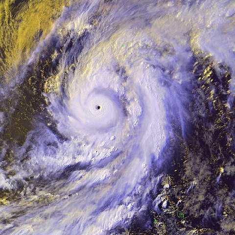
| Description | Severe tropical cyclone 01W, Damrey, was located near 16.4N 134.4E moving in a northeasterly direction at 13 knots. Maximum sustained winds were estimated at 130 knots, gusts to 160 knots. | |||
| Date | ||||
| Source | http://www.osei.noaa.gov/Events/Tropical/W_Pacific/2000/TRCdamrey130_N4.jpg | |||
| Author | NOAA / Operational Significant Event Imagery | |||
| Permission (Reusing this file) |
|
File history
Click on a date/time to view the file as it appeared at that time.
| Date/Time | Thumbnail | Dimensions | User | Comment | |
|---|---|---|---|---|---|
| current | 04:13, 12 December 2006 | | 800 × 800 (208 KB) | Good kitty (talk | contribs) | == Summary == {{Information |Description=Severe tropical cyclone 01W, Damrey, was located near 16.4N 134.4E moving in a northeasterly direction at 13 knots. Maximum sustained winds were estimated at 130 knots, gusts to 160 knots. |Source=http://www.osei.n |
You cannot overwrite this file.
File usage on Commons
There are no pages that use this file.
File usage on other wikis
The following other wikis use this file:
- Usage on ja.wikipedia.org
- Usage on vi.wikipedia.org
- Usage on zh.wikipedia.org