File:Typhoon Talas Terra MODIS picture 2011-09-02 annotated.jpg
Jump to navigation
Jump to search
No higher resolution available.
Typhoon_Talas_Terra_MODIS_picture_2011-09-02_annotated.jpg (720 × 480 pixels, file size: 165 KB, MIME type: image/jpeg)
Captions
Captions
Add a one-line explanation of what this file represents
Summary[edit]
| Description |
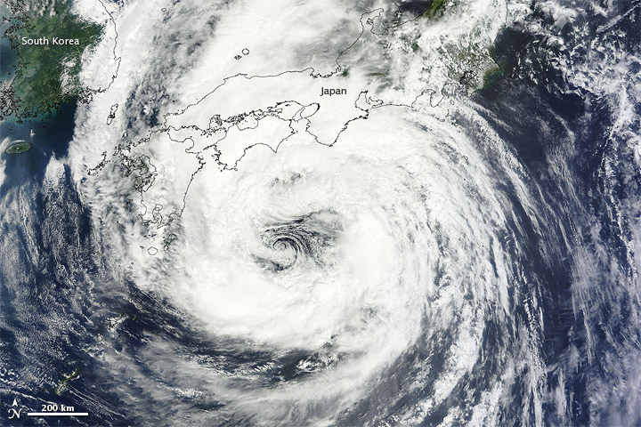
English: Typhoon Talas continued its northward journey over Japan on September 2, 2011. The Moderate Resolution Imaging Spectroradiometer (MODIS) on NASA’s Terra satellite acquired this natural-color image the same day.
On September 2, the U.S. Navy’s Joint Typhoon Warning Center reported that Talas had maximum sustained winds of 50 knots (95 kilometers per hour) and gusts up to 65 knots (120 kilometers per hour)—down slightly from speeds of the previous day. The storm was located roughly 185 nautical miles (345 kilometers) south-southwest of Kyoto, Japan. On September 2, the Japan Meteorological Agency (JMA) forecast that Talas would continue moving northward. As of September 3, the JMA estimated, Talas would likely have wind speeds roughly the same as those experienced on September 2. Deutsch: Taifun Talas setzte am 2. September seinen Weg nordwärts über Japan hinweg fort. Das Moderate Resolution Imaging Spectroradiometer (MODIS) auf dem Terra-Satelliten der NASA fertigte diese Bild in natürlichen Farben an jenem Tag an. Am 2 September meldete das Joint Typhoon Warning Center, daß Talas andauernde einminütige Windgeschwindigkeiten von 50 Knoten (95 Kilometer pro Stunde) und Windbögen von bis zu 65 Knoten (120 Kilometer pro Stunde) erreichte, was ein leichter Rückgang zu den Werten des Vortages darstellte. Der Sturm befand sich rund 185 Seemeilen (345 Kilometer) süd-südwestlich von Kyoto, Japan. Ebenfalls am 2. September sagte die Japan Meteorological Agency (JMA) voraus, daß Talas weiter nach Norden ziehen würde. Am 3. September, so schätzte die JMA, würden die Windgeschwindigkeiten von Talas etwa denen des 2. Septembers gleichen. |
| Date | |
| Source | http://earthobservatory.nasa.gov/NaturalHazards/view.php?id=52006 |
| Author | NASA image courtesy MODIS Rapid Response Team at NASA GSFC. Caption by Michon Scott. |
Licensing[edit]
| This file is in the public domain in the United States because it was solely created by NASA. NASA copyright policy states that "NASA material is not protected by copyright unless noted". (See Template:PD-USGov, NASA copyright policy page or JPL Image Use Policy.) | ||
 |
Warnings:
|
File history
Click on a date/time to view the file as it appeared at that time.
| Date/Time | Thumbnail | Dimensions | User | Comment | |
|---|---|---|---|---|---|
| current | 20:49, 11 September 2011 | | 720 × 480 (165 KB) | Matthiasb (talk | contribs) | {{Information |Description ={{en|1=Typhoon Talas continued its northward journey over Japan on September 2, 2011. The Moderate Resolution Imaging Spectroradiometer (MODIS) on NASA’s Terra satellite acquired this natural-color image the same day.<br/> |
You cannot overwrite this file.
File usage on Commons
There are no pages that use this file.
File usage on other wikis
The following other wikis use this file:
- Usage on de.wikinews.org