File:Typhoon Tip and Typhoon Sarah (1997).png
Jump to navigation
Jump to search
Size of this preview: 731 × 600 pixels. Other resolutions: 293 × 240 pixels | 585 × 480 pixels | 773 × 634 pixels.
Original file (773 × 634 pixels, file size: 836 KB, MIME type: image/png)
Captions
Captions
Add a one-line explanation of what this file represents
| Description |
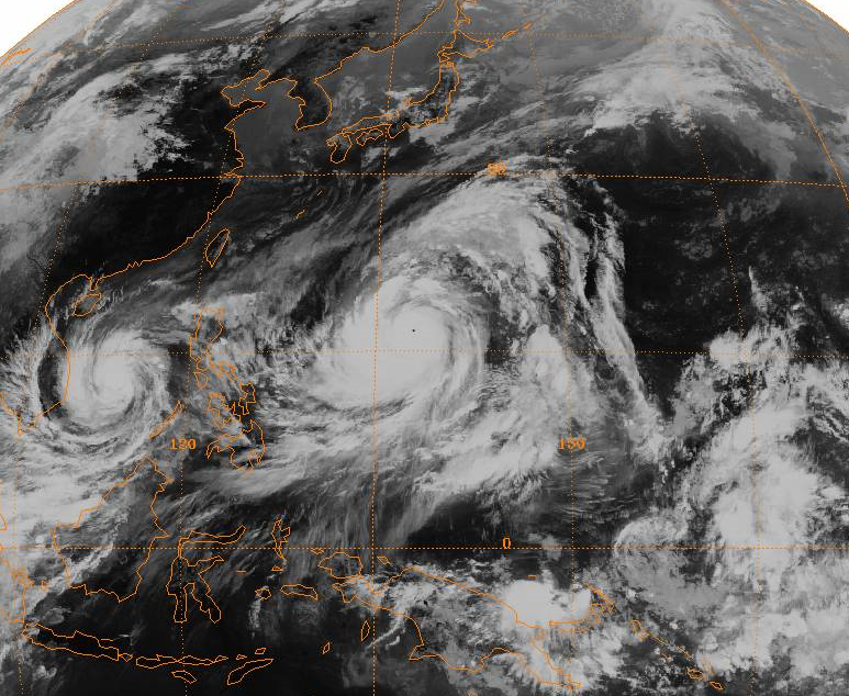
English: Full-disc satellite image of Typhoon Tip near its worldwide record peak intensity, located in the western Pacific Ocean. Typhoon Sarah is located to its west in the South China Sea. |
|||
| Date | ||||
| Source | http://www.ncdc.noaa.gov/gibbs/ | |||
| Author | GMS-1 Satellite | |||
| Permission (Reusing this file) |
|
File history
Click on a date/time to view the file as it appeared at that time.
| Date/Time | Thumbnail | Dimensions | User | Comment | |
|---|---|---|---|---|---|
| current | 01:24, 29 December 2008 | | 773 × 634 (836 KB) | Hurricanehink (talk | contribs) | {{Information |Description={{en|1=Full-disc satellite image of Typhoon Tip near its worldwide record peak intensity, located in the western Pacific Ocean. Typhoon Sarah is located to its west in the South China Sea.}} |Source=http://www.ncdc.noaa.gov/gibb |
You cannot overwrite this file.
File usage on Commons
The following page uses this file:
- File:Typhoon Tip full.PNG (file redirect)
File usage on other wikis
The following other wikis use this file:
- Usage on cs.wikipedia.org
- Usage on en.wikipedia.org
- Usage on hi.wikipedia.org
- Usage on ko.wikipedia.org
- Usage on ru.wikipedia.org
- Usage on simple.wikipedia.org
- Usage on uk.wikipedia.org
- Usage on vi.wikipedia.org
- Usage on zh.wikipedia.org
.png&oldid=665522850)