File:Typhoon Tip and Typhoon Sarah (1997).png
跳转到导航
跳转到搜索
本预览的尺寸:731 × 600像素。 其他分辨率:293 × 240像素 | 585 × 480像素 | 773 × 634像素。
原始文件 (773 × 634像素,文件大小:836 KB,MIME类型:image/png)
说明
说明
添加一行文字以描述该文件所表现的内容
| 描述 |
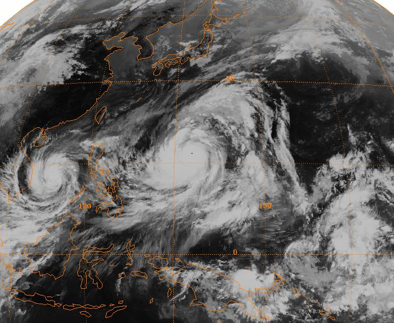
English: Full-disc satellite image of Typhoon Tip near its worldwide record peak intensity, located in the western Pacific Ocean. Typhoon Sarah is located to its west in the South China Sea. |
|||
| 日期 | ||||
| 来源 | http://www.ncdc.noaa.gov/gibbs/ | |||
| 作者 | GMS-1 Satellite | |||
| 授权 (二次使用本文件) |
|
文件历史
点击某个日期/时间查看对应时刻的文件。
| 日期/时间 | 缩略图 | 大小 | 用户 | 备注 | |
|---|---|---|---|---|---|
| 当前 | 2008年12月29日 (一) 01:24 | | 773 × 634(836 KB) | Hurricanehink(留言 | 贡献) | {{Information |Description={{en|1=Full-disc satellite image of Typhoon Tip near its worldwide record peak intensity, located in the western Pacific Ocean. Typhoon Sarah is located to its west in the South China Sea.}} |Source=http://www.ncdc.noaa.gov/gibb |
您不可以覆盖此文件。
文件用途
以下页面使用本文件:
- File:Typhoon Tip full.PNG(文件重定向)
全域文件用途
以下其他wiki使用此文件:
- cs.wikipedia.org上的用途
- en.wikipedia.org上的用途
- hi.wikipedia.org上的用途
- ko.wikipedia.org上的用途
- ru.wikipedia.org上的用途
- simple.wikipedia.org上的用途
- uk.wikipedia.org上的用途
- vi.wikipedia.org上的用途
- zh.wikipedia.org上的用途
.png&oldid=665522850)