File:U-Bahn Berlin - Netzplan.svg
跳至導覽
跳至搜尋

此 SVG 檔案的 PNG 預覽的大小:800 × 484 像素。 其他解析度:320 × 194 像素 | 640 × 387 像素 | 1,024 × 619 像素 | 1,280 × 774 像素 | 2,560 × 1,548 像素 | 1,660 × 1,004 像素。
原始檔案 (SVG 檔案,表面大小:1,660 × 1,004 像素,檔案大小:2.07 MB)
說明
說明
添加單行說明來描述出檔案所代表的內容
摘要
[編輯]| 描述 |
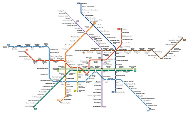
Deutsch: Netzplan der U-Bahn Berlin.
English: Map of the Berlin U-Bahn
Français : Plan du métro de Berlin.
Italiano: Mappa della metropolitana di Berlino.
中文:柏林地铁路线图 |
|||
| 來源 | 自己的作品 | |||
| 作者 | Arbalete | |||
| 授權許可 (重用此檔案) |
我,本作品的著作權持有者,決定用以下授權條款發佈本作品: 此檔案採用創用CC 姓名標示-相同方式分享 4.0 國際授權條款。
|
|||
| 其他版本 |
|


檔案歷史
點選日期/時間以檢視該時間的檔案版本。
| 日期/時間 | 縮圖 | 尺寸 | 使用者 | 備註 | |
|---|---|---|---|---|---|
| 目前 | 2023年4月19日 (三) 00:07 | | 1,660 × 1,004(2.07 MB) | Adrio(留言 | 貢獻) | Namen und Zusatzbezeichnungen an BVG-Netzplan angepasst; U6 bis 2025 nur bis Kurt-Schumacher-Platz |
| 2021年7月9日 (五) 16:02 |  | 1,660 × 1,004(2.15 MB) | Arbalete(留言 | 貢獻) | Update (new station Museumsinsel opened on 9th July 2021) | |
| 2021年6月8日 (二) 18:55 |  | 1,660 × 1,004(2.15 MB) | Arbalete(留言 | 貢獻) | Station korrigiert (Leopoldstraße → Leopoldplatz) | |
| 2020年12月5日 (六) 02:25 |  | 1,660 × 1,004(2.15 MB) | Arbalete(留言 | 貢獻) | Berliner Rathaus -> Rotes Rathaus | |
| 2020年12月2日 (三) 22:02 |  | 1,660 × 1,004(248 KB) | Arbalete(留言 | 貢獻) | New line U5 to Hauptbahnhof | |
| 2020年9月16日 (三) 16:23 |  | 1,660 × 1,004(338 KB) | Adrio(留言 | 貢獻) | Station korrigiert (Joachimsthaler → Johannisthaler) | |
| 2020年7月5日 (日) 13:03 |  | 1,660 × 1,004(251 KB) | Arbalete(留言 | 貢獻) | Uploaded own work with UploadWizard |
無法覆蓋此檔案。
檔案用途
下列27個頁面有用到此檔案:
- Berlin U-Bahn
- User:Arbalete/Maps
- User:Chumwa/OgreBot/Public transport information/2020 December 1-10
- User:Chumwa/OgreBot/Public transport information/2020 July 1-10
- User:Chumwa/OgreBot/Public transport information/2020 September 11-20
- User:Chumwa/OgreBot/Public transport information/2021 July 1-10
- User:Chumwa/OgreBot/Public transport information/2023 April 11-20
- User:Chumwa/OgreBot/Transport Maps/2020 December 1-10
- User:Chumwa/OgreBot/Transport Maps/2020 July 1-10
- User:Chumwa/OgreBot/Transport Maps/2020 September 11-20
- User:Chumwa/OgreBot/Transport Maps/2021 July 1-10
- User:Chumwa/OgreBot/Transport Maps/2023 April 11-20
- User:Clic/Nahverkehr in Deutschland/2020 December 1-10
- User:Clic/Nahverkehr in Deutschland/2020 July 1-10
- User:Clic/Nahverkehr in Deutschland/2020 September 11-20
- User:Clic/Nahverkehr in Deutschland/2021 July 1-10
- User:Clic/Nahverkehr in Deutschland/2023 April 11-20
- User:Jcornelius/Berlin rail transport/2023 April 11-20
- User:Nordlicht8/Rail Germany/2020 December 1-10
- User:Nordlicht8/Rail Germany/2020 July 1-10
- User:Nordlicht8/Rail Germany/2020 September 11-20
- User:Nordlicht8/Rail Germany/2021 July 1-10
- User:Nordlicht8/Rail Germany/2023 April 11-20
- User:Platte/Rail transport Berlin/2023 April
- File:U-Bahn Berlin - Netzplan.png
- Category:Berlin U-Bahn
- Category:Berlin U-Bahn lines
全域檔案使用狀況
以下其他 wiki 使用了這個檔案:
- ar.wikipedia.org 的使用狀況
- be-tarask.wikipedia.org 的使用狀況
- be.wikipedia.org 的使用狀況
- bg.wikipedia.org 的使用狀況
- ca.wikipedia.org 的使用狀況
- cs.wikipedia.org 的使用狀況
- da.wikipedia.org 的使用狀況
- de.wikipedia.org 的使用狀況
- en.wikipedia.org 的使用狀況
- eo.wikipedia.org 的使用狀況
- es.wikipedia.org 的使用狀況
- et.wikipedia.org 的使用狀況
- eu.wikipedia.org 的使用狀況
- fa.wikipedia.org 的使用狀況
- fa.wikivoyage.org 的使用狀況
- fi.wikipedia.org 的使用狀況
- fi.wikivoyage.org 的使用狀況
- fr.wikipedia.org 的使用狀況
- Métro de Berlin
- Alexanderplatz (métro de Berlin)
- Hauptbahnhof (métro de Berlin)
- Brandenburger Tor (métro de Berlin)
- Bundestag (métro de Berlin)
- Unter den Linden (métro de Berlin)
- Schillingstraße (métro de Berlin)
- Strausberger Platz (métro de Berlin)
- Weberwiese (métro de Berlin)
- Frankfurter Tor (métro de Berlin)
- Magdalenenstraße (métro de Berlin)
- Elsterwerdaer Platz (métro de Berlin)
- Cottbusser Platz (métro de Berlin)
- Friedrichsfelde (métro de Berlin)
- Tierpark (métro de Berlin)
- Biesdorf-Süd (métro de Berlin)
- Kienberg (métro de Berlin)
- Kaulsdorf-Nord (métro de Berlin)
- Wuhletal (métro de Berlin)
- Britz-Süd (métro de Berlin)
- Neukölln (métro de Berlin)
- Rotes Rathaus (métro de Berlin)
- Lichtenberg (métro de Berlin)
- Frankfurter Allee (métro de Berlin)
- Samariterstraße (métro de Berlin)
- Augsburger Straße (métro de Berlin)
檢視此檔案的更多全域使用狀況。