File:UCERF3 fig01-b.jpg
Zur Navigation springen
Zur Suche springen

Größe dieser Vorschau: 800 × 572 Pixel. Weitere Auflösungen: 320 × 229 Pixel | 640 × 457 Pixel | 1.024 × 732 Pixel | 1.280 × 915 Pixel | 2.088 × 1.492 Pixel.
Originaldatei (2.088 × 1.492 Pixel, Dateigröße: 727 KB, MIME-Typ: image/jpeg)
Bildtexte
Kurzbeschreibungen
Ergänze eine einzeilige Erklärung, was diese Datei darstellt.
| Beschreibung |
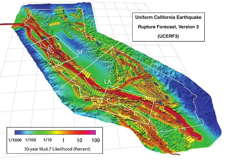
3D perspective view of California (outlined in white) and buffer zone showing the 2,606 fault sections of UCERF 3.1, with white boxes showing the San Francisco Bay (SF) and Los Angeles (LA) areas. Colors show the estimated probability of a section participating in one or more M ≥ 6.7 earthquakes in the 30 years following 2014, accounting for the current level of stress accumulated since the last earthquake. This version's scale uses percentages. Citation: WGCEP (2015-03), “UCERF3: A New Earthquake Forecast for California's Complex Fault System”, in U.S. Geological Survey[1], volume Fact Sheet 2015-3009, DOI:, ISSN 2327-6932 (online). |
|||
| Datum | ||||
| Quelle | http://pubs.usgs.gov/fs/2015/3009/pdf/fs2015-3009.pdf | |||
| Urheber | Created by the WGCEP 2014 team, a collaboration of the U.S. Geological Survey, the California Geological Survey, and the Southern California Earthquake Center. | |||
| Genehmigung (Weiternutzung dieser Datei) |
|
Dateiversionen
Klicke auf einen Zeitpunkt, um diese Version zu laden.
| Version vom | Vorschaubild | Maße | Benutzer | Kommentar | |
|---|---|---|---|---|---|
| aktuell | 18:59, 19. Apr. 2016 | | 2.088 × 1.492 (727 KB) | J. Johnson (Diskussion | Beiträge) | {{Information |Description= 3D perspective view of California (outlined in white) and buffer zone showing the 2,606 fault sections of UCERF 3.1, with white boxes showing the San Francisco Bay (SF) and Los Angeles (LA) areas. Colors show the estimated p... |
Du kannst diese Datei nicht überschreiben.
Dateiverwendung
Keine Seiten verwenden diese Datei.
Globale Dateiverwendung
Die nachfolgenden anderen Wikis verwenden diese Datei:
- Verwendung auf de.wikipedia.org
- Verwendung auf en.wikipedia.org
- Verwendung auf ja.wikipedia.org
- Verwendung auf ko.wikipedia.org
- Verwendung auf oc.wikipedia.org
- Verwendung auf uk.wikipedia.org