File:UK motorways map (thick lines).svg
跳至導覽
跳至搜尋

此 SVG 檔案的 PNG 預覽的大小:486 × 599 像素。 其他解析度:195 × 240 像素 | 389 × 480 像素 | 623 × 768 像素 | 831 × 1,024 像素 | 1,662 × 2,048 像素 | 1,038 × 1,279 像素。
原始檔案 (SVG 檔案,表面大小:1,038 × 1,279 像素,檔案大小:456 KB)
說明
說明
添加單行說明來描述出檔案所代表的內容
摘要
[編輯]| 描述 |
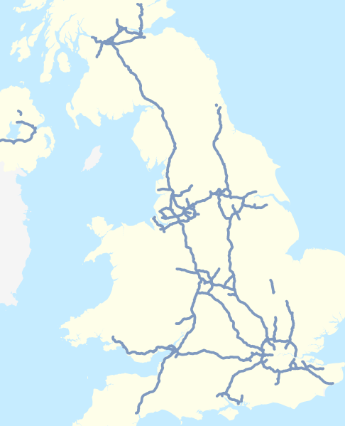
English: Map of the motorways of the United Kingdom in 2016 (including motorways under construction, not separately identified).
Equirectangular map projection on WGS 84 datum. |
| 日期 | |
| 來源 |
本檔案衍生自:
|
| 作者 |
|
| 其他版本 |
|


.svg&action=edit§ion=1)
.svg)
References
[編輯].svg&action=edit§ion=2)
Information about motorways under construction:
- Forth Replacement Crossing maps, Transport Scotland, accessed 2016-02-24
- M8 M73 M74 Improvements map, Transport Scotland, accessed 2016-02-24
- A1 Leeming to Barton Improvement archive copy at the Wayback Machine, Highways England, accessed 2016-02-24
授權條款
[編輯].svg&action=edit§ion=3)
| This work contains information from OpenStreetMap, which is made available under the Open Database License (ODbL).
The ODbL does not require any particular license for maps produced from ODbL data. Prior to 1 August 2020, map tiles produced by the OpenStreetMap Foundation were licensed under the CC-BY-SA-2.0 license. Maps produced by other people may be subject to other licences. |
此檔案採用創用CC 姓名標示-相同方式分享 4.0 國際授權條款。
姓名標示: Nilfanion and Dr Greg. © OpenStreetMap contributors. Contains Ordnance Survey data © Crown copyright and database right 2010.
- 您可以自由:
- 分享 – 複製、發佈和傳播本作品
- 重新修改 – 創作演繹作品
- 惟需遵照下列條件:
- 姓名標示 – 您必須指名出正確的製作者,和提供授權條款的連結,以及表示是否有對內容上做出變更。您可以用任何合理的方式來行動,但不得以任何方式表明授權條款是對您許可或是由您所使用。
- 相同方式分享 – 如果您利用本素材進行再混合、轉換或創作,您必須基於如同原先的相同或兼容的條款,來分布您的貢獻成品。
檔案歷史
點選日期/時間以檢視該時間的檔案版本。
| 日期/時間 | 縮圖 | 尺寸 | 使用者 | 備註 | |
|---|---|---|---|---|---|
| 目前 | 2016年2月25日 (四) 17:27 | | 1,038 × 1,279(456 KB) | Dr Greg(留言 | 貢獻) | User created page with UploadWizard |
無法覆蓋此檔案。
檔案用途
下列40個頁面有用到此檔案:
- User:Chumwa/OgreBot/Transport Maps/2016 February 20-29
- User:Chumwa/OgreBot/Travel and communication maps/2016 February 20-29
- File:A1(M) motorway (Great Britain) map.svg
- File:A74(M) motorway (Great Britain) map.svg
- File:M11 motorway (Great Britain) map.svg
- File:M180 motorway (Great Britain) map.svg
- File:M18 motorway (Great Britain) map.svg
- File:M1 motorway (Great Britain) map.svg
- File:M1 motorway (Northern Ireland) map.svg
- File:M20 motorway (Great Britain) map.svg
- File:M23 motorway (Great Britain) map.svg
- File:M25 motorway (Great Britain) map.svg
- File:M27 motorway (Great Britain) map.svg
- File:M2 motorway (Great Britain) map.svg
- File:M2 motorway (Northern Ireland) map.svg
- File:M3 motorway (Great Britain) map.svg
- File:M40 motorway (Great Britain) map.svg
- File:M42 motorway (Great Britain) map.svg
- File:M4 motorway (Great Britain) map.svg
- File:M50 motorway (Great Britain) map.svg
- File:M53 motorway (Great Britain) map.svg
- File:M54 motorway (Great Britain) map.svg
- File:M55 motorway (Great Britain) map.svg
- File:M56 motorway (Great Britain) map.svg
- File:M5 motorway (Great Britain) map.svg
- File:M60 motorway (Great Britain) map.svg
- File:M61 motorway (Great Britain) map.svg
- File:M62 motorway (Great Britain) map.svg
- File:M65 motorway (Great Britain) map.svg
- File:M69 motorway (Great Britain) map.svg
- File:M6 Toll motorway (Great Britain) map.svg
- File:M6 motorway (Great Britain) map.svg
- File:M74 motorway (Great Britain) map.svg
- File:M77 motorway (Great Britain) map.svg
- File:M80 motorway (Great Britain) map.svg
- File:M8 motorway (Great Britain) map.svg
- File:M90 motorway (Great Britain) map.svg
- File:M9 motorway (Great Britain) map.svg
- File:Motorways in North West England map.svg
- File:UK motorways map (pale lines).svg
_motorway_(Great_Britain)_map.svg)
_motorway_(Great_Britain)_map.svg)
_map.svg)
_map.svg)
_map.svg)
_map.svg)
_map.svg)
_map.svg)
_map.svg)
_map.svg)
_map.svg)
_map.svg)
_map.svg)
_map.svg)
_map.svg)
_map.svg)
_map.svg)
_map.svg)
_map.svg)
_map.svg)
_map.svg)
_map.svg)
_map.svg)
_map.svg)
_map.svg)
_map.svg)
_map.svg)
_map.svg)
_map.svg)
_map.svg)
_map.svg)
_map.svg)
_map.svg)
_map.svg)
_map.svg)
_map.svg)
全域檔案使用狀況
以下其他 wiki 使用了這個檔案:
- en.wikipedia.org 的使用狀況
- M25 motorway
- List of roads and highways
- List of motorways in the United Kingdom
- M11 motorway
- A3 road
- M6 motorway
- M1 motorway
- M45 motorway
- M60 motorway (Great Britain)
- M4 motorway
- A41 road
- M40 motorway
- M3 motorway (Great Britain)
- Westway (London)
- M62 motorway
- M67 motorway
- M2 motorway (Great Britain)
- M5 motorway
- M8 motorway (Scotland)
- M9 motorway (Scotland)
- M18 motorway (Great Britain)
- M20 motorway
- M56 motorway
- A74(M) and M74 motorways
- A66 road
- M23 motorway
- M27 motorway
- M42 motorway
- M53 motorway
- M90 motorway
- M180 motorway
- M65 motorway
- M61 motorway
- M69 motorway
- M6 Toll
- A6144(M) motorway
- Spaghetti Junction, Birmingham
- M32 motorway
- M48 motorway
- M49 motorway
- M50 motorway (England)
- A38(M) motorway
- M10 motorway (Great Britain)
- M26 motorway
- M55 motorway
- M57 motorway
- M58 motorway
- M66 motorway
- M73 motorway
- M77 motorway
檢視此檔案的更多全域使用狀況。
.svg)
.svg&oldid=803432166)