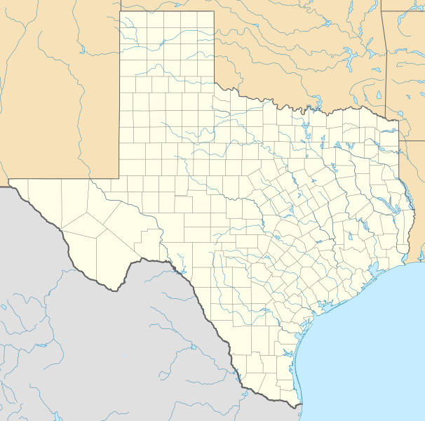
File:USA Texas location map.svg
出自Wikimedia Commons
跳至導覽
跳至搜尋

此 SVG 檔案的 PNG 預覽的大小:606 × 600 像素。 其他解析度:243 × 240 像素 | 485 × 480 像素 | 776 × 768 像素 | 1,035 × 1,024 像素 | 2,070 × 2,048 像素 | 1,500 × 1,484 像素。
原始檔案 (SVG 檔案,表面大小:1,500 × 1,484 像素,檔案大小:695 KB)
檔案資訊
結構化資料
說明
說明
添加單行說明來描述出檔案所代表的內容
نقشه ایالت تگزاس، آمریکا
Lokasi negara bagian Texas, Amerika Serikat
Location of Texas, USA
摘要
[編輯]| 描述USA Texas location map.svg |
Quadratische Plattkarte, N-S-Streckung 120 %. Geographische Begrenzung der Karte:
Equirectangular projection, N/S stretching 120 %. Geographic limits of the map:
本image使用GeoTools創作。 |
| 日期 | |
| 來源 | 自己的作品 |
| 作者 | Alexrk |
| 其他版本 |
Derivative works of this file: |

|
azərbaycanca ∙ čeština ∙ Deutsch ∙ Deutsch (Sie-Form) ∙ English ∙ español ∙ français ∙ italiano ∙ latviešu ∙ magyar ∙ Nederlands ∙ Plattdüütsch ∙ polski ∙ português ∙ română ∙ sicilianu ∙ slovenščina ∙ suomi ∙ македонски ∙ русский ∙ ქართული ∙ հայերեն ∙ বাংলা ∙ ไทย ∙ +/−
|
授權條款
[編輯]我,本作品的著作權持有者,決定用以下授權條款發佈本作品:

|
已授權您依據自由軟體基金會發行的無固定段落、封面文字和封底文字GNU自由文件授權條款1.2版或任意後續版本,對本檔進行複製、傳播和/或修改。該協議的副本列在GNU自由文件授權條款中。http://www.gnu.org/copyleft/fdl.htmlGFDLGNU Free Documentation Licensetruetrue |
此檔案採用創用CC 姓名標示 3.0 未在地化版本授權條款。
- 您可以自由:
- 分享 – 複製、發佈和傳播本作品
- 重新修改 – 創作演繹作品
- 惟需遵照下列條件:
- 姓名標示 – 您必須指名出正確的製作者,和提供授權條款的連結,以及表示是否有對內容上做出變更。您可以用任何合理的方式來行動,但不得以任何方式表明授權條款是對您許可或是由您所使用。
您可以選擇您需要的授權條款。
檔案歷史
點選日期/時間以檢視該時間的檔案版本。
| 日期/時間 | 縮圖 | 尺寸 | 使用者 | 備註 | |
|---|---|---|---|---|---|
| 目前 | 2009年6月17日 (三) 20:30 |  | 1,500 × 1,484(695 KB) | Alexrk2(留言 | 貢獻) | enh |
| 2009年6月7日 (日) 13:05 |  | 1,500 × 1,484(558 KB) | Alexrk(留言 | 貢獻) | water bodies 1:10mio | |
| 2009年6月6日 (六) 21:43 |  | 1,500 × 1,484(850 KB) | Alexrk(留言 | 貢獻) | GeneralizationDistance = 2px | |
| 2009年6月6日 (六) 17:41 |  | 1,500 × 1,485(1.48 MB) | Alexrk(留言 | 貢獻) | == Beschreibung == {{Information |Description= {{de|Positionskarte von Texas, USA}} Quadratische Plattkarte, N-S-Streckung 120 %. Geographische Begrenzung der Karte: * N: 36.8° N * S: 25.5° N * W: 106.9° W * O: 93.2° W {{en|L |
無法覆蓋此檔案。
檔案用途
下列19個頁面有用到此檔案:
- File:Checkers and Rally's footprint.png
- File:Citgo locations 2020 September.png
- File:Costco footprint map USA 2021-01.png
- File:Dollar Tree footprint map 2020-12.png
- File:Family Dollar footprint map 2020-12.png
- File:Kum&GoFootprint July2020.png
- File:QuikTrip Footprint 2020 October.png
- File:RaceTrac+RaceWay footprint 2020-01.png
- File:RaceTrac US footprint.png
- File:RaceWay US footprint.png
- File:Rooms To Go footprint map 2021-01.png
- File:Save-A-Lot footprint map.png
- File:Speedway Footprint 2020 August.png
- File:Speedway Jun2018 to Aug2020 comparison.png
- File:Target stores footprint 2020-12.png
- File:Texas proposed boundaries.svg
- File:Valero brands branded gas stations 2020-12.png
- File:Walmart branded fuel stations map 2020-12.png
- File:Walmart locations with on-site fuel stations map 2020-20.png
全域檔案使用狀況
以下其他 wiki 使用了這個檔案:
- af.wikipedia.org 的使用狀況
- als.wikipedia.org 的使用狀況
- an.wikipedia.org 的使用狀況
- ar.wikipedia.org 的使用狀況
- ast.wikipedia.org 的使用狀況
- azb.wikipedia.org 的使用狀況
- سایپرس، تکزاس
- ونکورت، تکزاس
- شابلون:Location map Texas
- لوپ، تکزاس
- اوریسن، تکزاس
- لاس پالماس ۲، تکزاس
- قلیدن، تکزاس
- آنیون کریک، آستین، تکزاس
- کوپلند، تکزاس
- ساوانا، تکزاس
- آرویو قاردنز-لاتینا رنچ، تکزاس
- تییرا بونتیا، تکزاس
- لیک مردیت استیتس، تکزاس
- منچاکا، تکزاس
- باوزل اند الیس، تکزاس
- وست پیرسال، تکزاس
- بونانزا هیلز، تکزاس
- تاندربیرد بی، تکزاس
- لاس پالماس، تکزاس
- آریو آلتو، تکزاس
- پینت کریت، تکزاس
- مونتاژ، تکزاس
- پالوما کریک ساوت، تکزاس
- کولورادو ایکرز، تکزاس
- امارقوسا، تکزاس
- لینکلن، تکزاس
- نورتکلیف، تکزاس
檢視此檔案的更多全域使用狀況。
詮釋資料
此檔案中包含其他資訊,這些資訊可能是由數位相機或掃描器在建立或數位化過程中所新增的。若檔案自原始狀態已被修改,一些詳細資料可能無法完整反映出已修改的檔案。
| 寬度 | 1500 |
|---|---|
| 高度 | 1484 |