File:USA Virginia location map.svg
跳转到导航
跳转到搜索

此SVG文件的PNG预览的大小:800 × 514像素。 其他分辨率:320 × 206像素 | 640 × 411像素 | 1,024 × 658像素 | 1,280 × 823像素 | 2,560 × 1,645像素 | 1,500 × 964像素。
原始文件 (SVG文件,尺寸为1,500 × 964像素,文件大小:941 KB)
说明
说明
添加一行文字以描述该文件所表现的内容
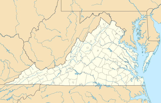
Location map of the state of Virginia.
摘要
[编辑]| 描述 |
Quadratische Plattkarte, N-S-Streckung 130.0 %. Geographische Begrenzung der Karte:
Equirectangular projection, N/S stretching 130.0 %. Geographic limits of the map:
|
| 日期 | |
| 来源 | 自己的作品 |
| 作者 | Alexrk2 |
| 其他版本 |
此文件衍生的作品: Wawa footprint 2012-07.png 此文件衍生的作品: |
| SVG开发 |

许可协议
[编辑]
我,本作品著作权人,特此采用以下许可协议发表本作品:

|
已授权您依据自由软件基金会发行的无固定段落及封面封底文字(Invariant Sections, Front-Cover Texts, and Back-Cover Texts)的GNU自由文件许可协议1.2版或任意后续版本的条款,复制、传播和/或修改本文件。该协议的副本请见“GNU Free Documentation License”。 |
本文件采用知识共享署名 3.0 未本地化版本许可协议授权。
- 您可以自由地:
- 共享 – 复制、发行并传播本作品
- 修改 – 改编作品
- 惟须遵守下列条件:
- 署名 – 您必须对作品进行署名,提供授权条款的链接,并说明是否对原始内容进行了更改。您可以用任何合理的方式来署名,但不得以任何方式表明许可人认可您或您的使用。
您可以选择您需要的许可协议。
文件历史
点击某个日期/时间查看对应时刻的文件。
| 日期/时间 | 缩略图 | 大小 | 用户 | 备注 | |
|---|---|---|---|---|---|
| 当前 | 2017年1月1日 (日) 14:20 | | 1,500 × 964(941 KB) | Maproom(留言 | 贡献) | Removed Bedford, as no longer a city. Edit requested at https://en.wikipedia.org/wiki/Wikipedia:Graphics_Lab/Map_workshop#Remove_a_no-longer-extant_city |
| 2009年7月6日 (一) 18:02 |  | 1,500 × 964(941 KB) | Alexrk2(留言 | 贡献) | resize | |
| 2009年6月26日 (五) 16:42 |  | 1,201 × 772(944 KB) | Alexrk2(留言 | 贡献) | == Beschreibung == {{Information |Description= {{de|Positionskarte von Virginia, USA}} Quadratische Plattkarte, N-S-Streckung 130.0 %. Geographische Begrenzung der Karte: * N: 40.2° N * S: 35.8° N * W: 83.9° W * O: 75.0° W |
您不可以覆盖此文件。
文件用途
以下34个页面使用本文件:
- File:BJ's Gas Station locations 2020 December.png
- File:BJ's store locations.png
- File:BJ's store locations 2020 December.png
- File:Checkers and Rally's footprint.png
- File:Citgo locations 2020 September.png
- File:Convenience stores of Mid-Atlantic.png
- File:Costco footprint map USA 2021-01.png
- File:Dollar Tree footprint map 2020-12.png
- File:Family Dollar footprint map 2020-12.png
- File:GetGo20-01.png
- File:Harris Teeter footprint 2020-12.png
- File:Harris Teeter footprint 2020-12 fuel.png
- File:M&T Bank footprint.png
- File:Publix footprint 2020 November.png
- File:QuikTrip Footprint 2020 October.png
- File:RaceTrac+RaceWay footprint 2020-01.png
- File:RaceTrac US footprint.png
- File:RaceWay US footprint.png
- File:Rooms To Go footprint map 2021-01.png
- File:Royal Farms stores footprint map.png
- File:Save-A-Lot footprint map.png
- File:Somerset Trust footprint 2020-12.png
- File:Speedway Footprint 2020 August.png
- File:Speedway Jun2018 to Aug2020 comparison.png
- File:Target stores footprint 2020-12.png
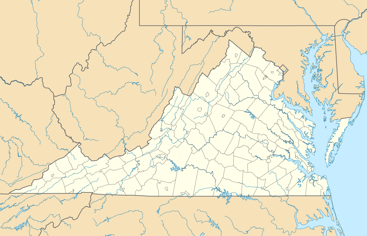
- File:USA Virginia relief location map.svg
- File:Valero brands branded gas stations 2020-12.png
- File:Walmart branded fuel stations map 2020-12.png
- File:Walmart locations with on-site fuel stations map 2020-20.png
- File:Wawa footprint 2012-07.png
- File:Wawa footprint 2019-10.png
- File:Wawa footprint 2019-12.png
- File:Wawa footprint 2019-12 (fuel locations).png
- File:Wawa footprint 2019-12 (non-fuel locations).png
.png)
.png)
全域文件用途
以下其他wiki使用此文件:
- an.wikipedia.org上的用途
- ar.wikipedia.org上的用途
- ast.wikipedia.org上的用途
- azb.wikipedia.org上的用途
- بیرینجی آوبرن دؤیوشو
- برمو بلاف، ویرجینیا
- کروزت، ویرجینیا
- ویندام، ویرجینیا
- لیمنتاون، ویرجینیا
- لیک کارولینا، ویرجینیا
- کارزویل، ویرجینیا
- ویلا هایتس، ویرجینیا
- کلوردیل، ویرجینیا
- ماسانتا اسپرینقز، ویرجینیا
- مکمولین، ویرجینیا
- تمپلتون، ویرجینیا
- بلند، ویرجینیا
- ناتالی، ویرجینیا
- الیستون-لافایت، ویرجینیا
- مریماک، ویرجینیا
- اسپری ویل، ویرجینیا
- کتاوبا، ویرجینیا
- پنتاپس، ویرجینیا
- بردشا، ویرجینیا
- اسکایلر، ویرجینیا
- الیستون، ویرجینیا
- چارلز سیتی، ویرجینیا
- هنری فورک، ویرجینیا
- تویین لیک، ویرجینیا
- یوقاویل، ویرجینیا
- دینویدی، ویرجینیا
- مدیلبروک، ویرجینیا
- اسکاتلند، ویرجینیا
- بریسی، ویرجینیا
- تاینادیل، ویرجینیا
- ماساناتن، ویرجینیا
- چرچویل، ویرجینیا
- فری یونیون، ویرجینیا
- کلوور، ویرجینیا
- دانته، ویرجینیا
- یونیون لول، ویرجینیا
- شاونی لند، ویرجینیا
- میدوبروک، ویرجینیا
- دیلویل، ویرجینیا
- ریون، ویرجینیا
- کاپرهیل، ویرجینیا
- سندی لول، ویرجینیا
- پنهوک، ویرجینیا
查看此文件的更多全域用途。