File:USGS Sunda Trench.JPG
跳转到导航
跳转到搜索
没有更高的分辨率。
USGS_Sunda_Trench.JPG (611 × 461像素,文件大小:62 KB,MIME类型:image/jpeg)
说明
说明
添加一行文字以描述该文件所表现的内容
摘要
[编辑]
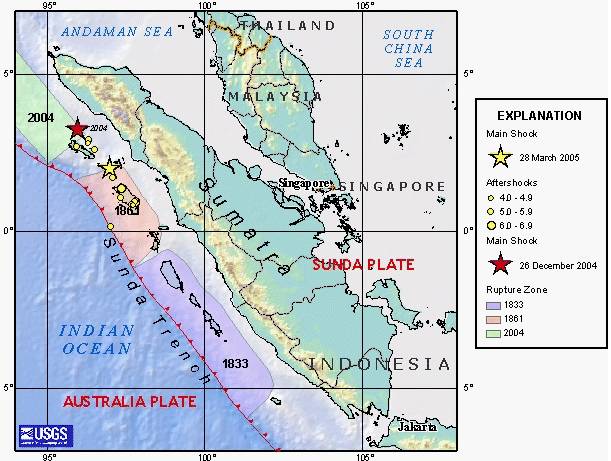
| 描述 | en:USGS image depicting en:earthquake zones for the en:Sunda Trench - en:1833, en:1861, en:26 December en:2004 Indian Ocean earthquake, and en:28 March en:2005 Sumatran earthquake. |
| 来源 | |
| 作者 |
许可协议
[编辑]
|
|
原始上传日志
[编辑]
The original description page was here. All following user names refer to en.wikipedia.
- 2005-03-31 03:57 Peter Ellis 611×461×8 (63844 bytes) [[USGS]] image depicting [[earthquake]] zones for the [[Sunda Trench]] - [[1833]], [[1861]], [[26 December]] [[2004 Indian Ocean earthquake]], and [[28 March]] [[2005 Sumatran earthquake]]. {{PD-USGov-Interior-USGS}}
文件历史
点击某个日期/时间查看对应时刻的文件。
| 日期/时间 | 缩略图 | 大小 | 用户 | 备注 | |
|---|---|---|---|---|---|
| 当前 | 2007年10月9日 (二) 11:34 | | 611 × 461(62 KB) | Matthiasb(留言 | 贡献) | {{Information |Description=en:USGS image depicting en:earthquake zones for the en:Sunda Trench - en:1833, en:1861, en:26 December en:2004 Indian Ocean earthquake, and en:28 March en:2005 Sumatran earthquake. |S |
您不可以覆盖此文件。
文件用途
全域文件用途
以下其他wiki使用此文件:
- bn.wikipedia.org上的用途
- ca.wikipedia.org上的用途
- cs.wikipedia.org上的用途
- de.wikipedia.org上的用途
- en.wikipedia.org上的用途
- es.wikipedia.org上的用途
- id.wikipedia.org上的用途
- ko.wikipedia.org上的用途
- lt.wikipedia.org上的用途
- ms.wikipedia.org上的用途
- su.wikipedia.org上的用途
- sv.wikipedia.org上的用途
- vi.wikipedia.org上的用途
- www.wikidata.org上的用途
- zh.wikipedia.org上的用途