File:USS Triton SSRN-586 circumnavigation map 1960.jpg
Jump to navigation
Jump to search

Size of this preview: 502 × 599 pixels. Other resolutions: 201 × 240 pixels | 402 × 480 pixels | 643 × 768 pixels | 1,024 × 1,222 pixels.
Original file (1,024 × 1,222 pixels, file size: 544 KB, MIME type: image/jpeg)
Captions
Captions
Add a one-line explanation of what this file represents
Summary
[edit]
| Description |
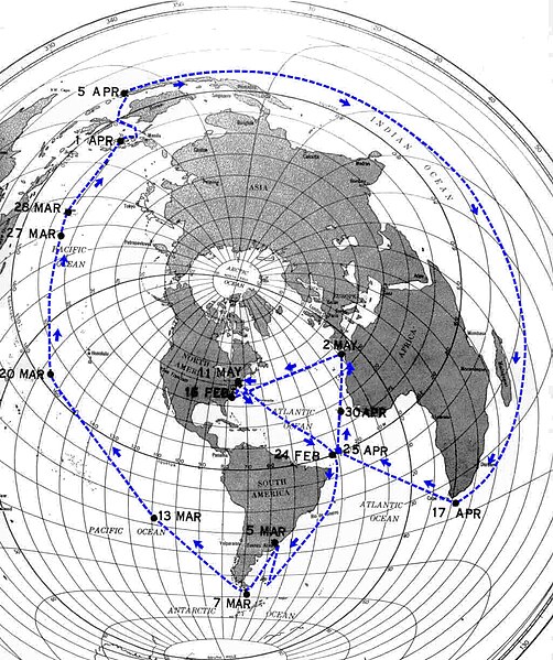
English: Map of the 1960 circumnavigation of the world by the U.S. nuclear-powered submarine USS Triton (SSRN-586) |
| Date | |
| Source | Unofficial USS Triton Web Site |
| Author | U.S. Navy |
| Permission (Reusing this file) |
Public Domain |
Licensing
[edit]
This file is a work of a sailor or employee of the U.S. Navy, taken or made as part of that person's official duties. As a work of the U.S. federal government, it is in the public domain in the United States.
|
 | |
| This file has been identified as being free of known restrictions under copyright law, including all related and neighboring rights. | ||
File history
Click on a date/time to view the file as it appeared at that time.
| Date/Time | Thumbnail | Dimensions | User | Comment | |
|---|---|---|---|---|---|
| current | 17:41, 28 March 2019 | | 1,024 × 1,222 (544 KB) | Hohum (talk | contribs) | Crop |
| 17:39, 28 March 2019 |  | 1,024 × 1,292 (390 KB) | Hohum (talk | contribs) | Colour | |
| 17:18, 28 March 2019 |  | 1,024 × 1,292 (290 KB) | Hohum (talk | contribs) | Adjust brightness curve | |
| 22:27, 27 March 2019 |  | 1,024 × 1,292 (141 KB) | Hohum (talk | contribs) | Clearer, full version | |
| 21:06, 27 February 2010 |  | 770 × 833 (43 KB) | Marcd30319 (talk | contribs) | {{Information |Description={{en|1=Map of the 1960 circumnavigation of the world by the U.S. nuclear-powered submarine USS ''Triton'' (SSRN-586)}} |Source=[http://garrygray.tripod.com/atws/around_the_world_submerged.htm Unofficial USS ''Triton'' Web Site] |
You cannot overwrite this file.
File usage on Commons
The following 6 pages use this file:
- User:Adeletron 3030/botgalleries/Sports/2019 March 26-28
- User:Chumwa/OgreBot/Potential transport maps/2019 March 21-31
- User:Chumwa/OgreBot/Transport Maps/2019 March 21-31
- User:Chumwa/OgreBot/Travel and communication maps/2019 March 21-31
- User:OgreBot/Watercraft/2019 March 27
- User:OgreBot/Watercraft/2019 March 28
File usage on other wikis
The following other wikis use this file:
- Usage on en.wikipedia.org
- Usage on pt.wikipedia.org
- Usage on ru.wikipedia.org
- Usage on uk.wikipedia.org