File:US Navy 110315-N-IC111-592 - Tsunami damage of Rikuzentakata.jpg
跳至導覽
跳至搜尋

預覽大小:800 × 531 像素。 其他解析度:320 × 213 像素 | 640 × 425 像素 | 1,024 × 680 像素 | 1,280 × 850 像素 | 2,560 × 1,700 像素 | 4,288 × 2,848 像素。
原始檔案 (4,288 × 2,848 像素,檔案大小:3 MB,MIME 類型:image/jpeg)
說明
說明
添加單行說明來描述出檔案所代表的內容
摘要[編輯]
| 描述 |
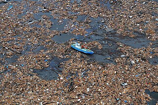
English: Rikuzentakata, Iwate Prefecture, Japan (March 15, 2011). --- An aerial view of damage to Rikuzentakata, Japan after a 9.0 magnitude earthquake and subsequent tsunami devastated the area in northern Japan. Ships and aircraft from the Ronald Reagan Carrier Strike Group are conducting search and rescue operations and re-supply missions as directed in support of Operation Tomodachi throughout northern Japan. (U.S. Navy photo by Mass Communication Specialist 3rd Class Alexander Tidd/Released)
日本語: 岩手県陸前高田市小友町の空撮。漁船がある位置は小友駅から北北西300mほどの場所。原典にはWAKUYA(涌谷町)とあるがこれは間違いである。場所の同定についてはUser:Batholithが国土地理院地図の航空写真で確認したものである。 |
|||
| 日期 | 攝於2011年3月15日 | |||
| 來源 |
|
|||
| 作者 | U.S. Navy photo by Mass Communication Specialist 3rd Class Alexander Tidd |

| 目標地點 | | 位於此地的本圖片與其他圖片: OpenStreetMap |
|---|
授權條款[編輯]
 | ||
| 此作品無已知的著作權限制,亦不受所有相關和鄰接的權利限制。 | ||
檔案歷史
點選日期/時間以檢視該時間的檔案版本。
| 日期/時間 | 縮圖 | 尺寸 | 使用者 | 備註 | |
|---|---|---|---|---|---|
| 目前 | 2011年3月17日 (四) 01:58 | | 4,288 × 2,848(3 MB) | BotMultichillT(留言 | 貢獻) | == {{int:filedesc}} == {{Information |description={{en|1=WAKUYA, Japan (March 15, 2011) An aerial view of damage to Wakuya, Japan after a 9.0 magnitude earthquake and subsequent tsunami devastated the area in northern Japan. Ships and aircraft from the Ro |
無法覆蓋此檔案。
檔案用途
下列3個頁面有用到此檔案:
- File:Flickr - Official U.S. Navy Imagery - Aerial of damage to Wakuya, Japan..jpg (檔案重新導向)
- File:US Navy 110315-N-IC111-592 An aerial view of damage to Rikuzentakata, Japan after a 9.0 magnitude earthquake and subsequent tsunami devastated the area in.jpg (檔案重新導向)
- File:US Navy 110315-N-IC111-592 An aerial view of damage to Wakuya, Japan after a 9.0 magnitude earthquake and subsequent tsunami devastated the area in.jpg (檔案重新導向)
全域檔案使用狀況
以下其他 wiki 使用了這個檔案:
- cs.wikipedia.org 的使用狀況
- zh.wikipedia.org 的使用狀況