File:US Navy 110320-N-OB360-166 An aerial view of ships washed ashore and overturned at a port near the Japan Air Self-Defense Force Matsushima Air Base.jpg
跳转到导航
跳转到搜索
本预览的尺寸:800 × 531像素。 其他分辨率:320 × 212像素 | 640 × 425像素 | 1,024 × 680像素 | 1,280 × 850像素 | 2,500 × 1,660像素。
原始文件 (2,500 × 1,660像素,文件大小:835 KB,MIME类型:image/jpeg)
说明
说明
添加一行文字以描述该文件所表现的内容
摘要[编辑]
| 描述 |
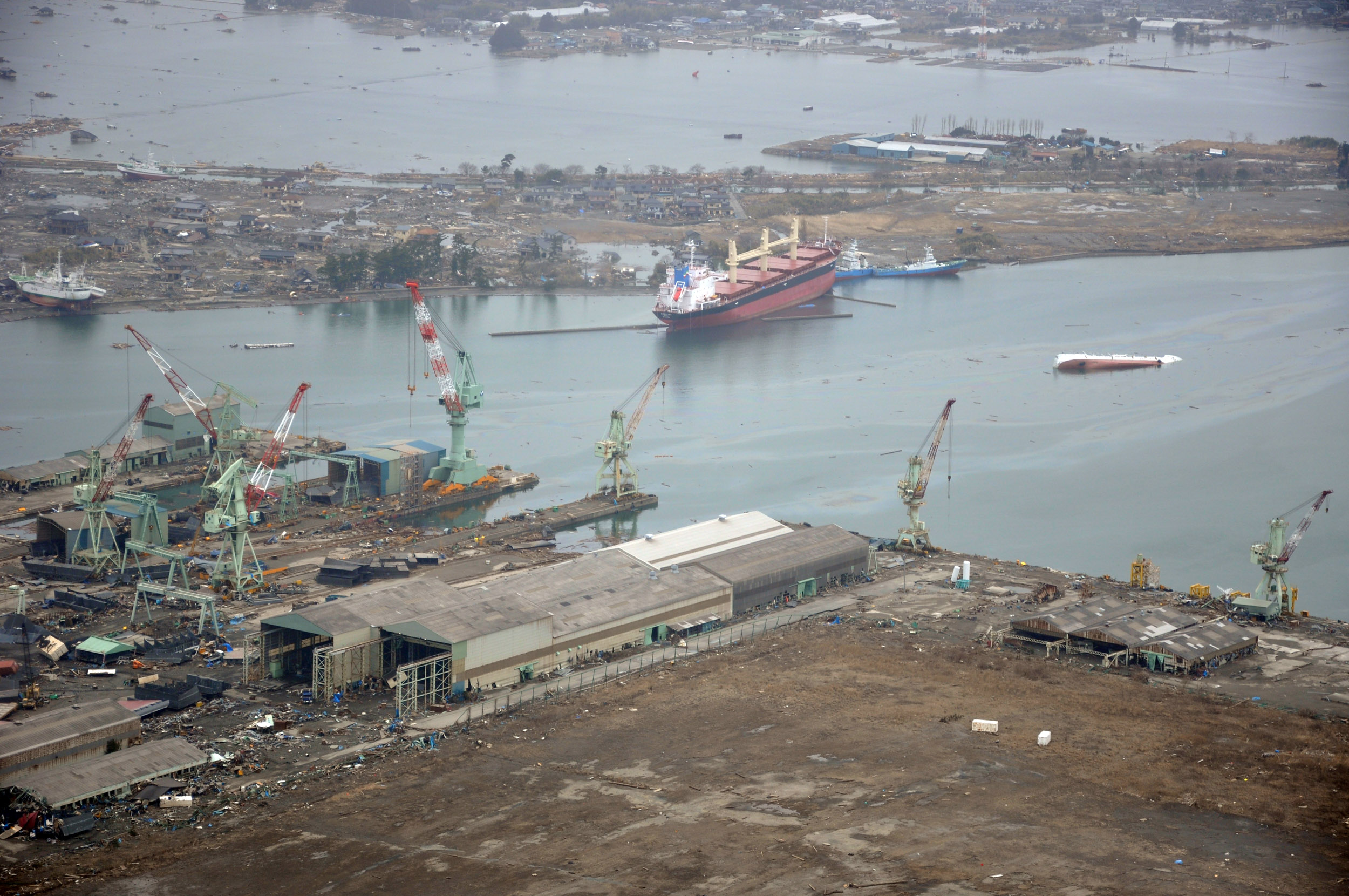
English: NORTHERN JAPAN (March 20, 2011) An aerial view of ships washed ashore and overturned at the port of Ishinomaki near the Japan Air Self-Defense Force Matsushima Air Base. The air base is serving as a refueling station for CH-46 Sea Knight helicopters assigned to Marine Medium Helicopter Squadron (HMM) 265 as they conduct humanitarian assistance missions in Northern Japan as part of Operation Tomodachi. (U.S. navy photo by Mass Communication Specialist 1st Class Ben Farone/Released)
|
|||
| 日期 | 摄于2011年3月20日 | |||
| 来源 |
|
|||
| 作者 | U.S. navy photo by Mass Communication Specialist 1st Class Ben Farone |

| 相机位置 | | 在以下服务上查看本图像和附近其他图像: OpenStreetMap |
|---|
许可协议[编辑]
 | ||
| 本文件已被确认为免除已知的著作权法限制(包括所有相关权利)。 | ||
文件历史
点击某个日期/时间查看对应时刻的文件。
| 日期/时间 | 缩略图 | 大小 | 用户 | 备注 | |
|---|---|---|---|---|---|
| 当前 | 2011年3月22日 (二) 02:14 | | 2,500 × 1,660(835 KB) | BotMultichillT(留言 | 贡献) | == {{int:filedesc}} == {{Information |description={{en|1=NORTHERN JAPAN (March 20, 2011) An aerial view of ships washed ashore and overturned at a port near the Japan Air Self-Defense Force Matsushima Air Base. The air base is serving as a refueling stat |
您不可以覆盖此文件。
文件用途
以下页面使用本文件:
全域文件用途
以下其他wiki使用此文件:
- de.wikipedia.org上的用途
- en.wikipedia.org上的用途
- fr.wikipedia.org上的用途
- ja.wikipedia.org上的用途
- ko.wikipedia.org上的用途
- ms.wikipedia.org上的用途
- nl.wikipedia.org上的用途
- tl.wikipedia.org上的用途
- tr.wikipedia.org上的用途
- zh.wikipedia.org上的用途
元数据
分类:
- United States Navy images from Miyagi prefecture
- 2011 Tōhoku earthquake damage and effects in Ishinomaki, Miyagi
- Grounded ships by the 2011 Tōhoku tsunami in Japan
- Debris of the 2011 Tohoku tsunami
- Aerial photographs of Miyagi prefecture
- Aerial photographs of ports and harbours in Japan
- Port of Ishinomaki
- Yamanishi
- Shipwrecks in Japan
- C.S. Victory (ship, 2003)
- Teizan Canal
- Overturned vehicles
- Nishihamachō, Ishinomaki