File:US insular areas - fr.svg
Jump to navigation
Jump to search

Size of this PNG preview of this SVG file: 800 × 341 pixels. Other resolutions: 320 × 136 pixels | 640 × 273 pixels | 1,024 × 436 pixels | 1,280 × 545 pixels | 2,560 × 1,091 pixels | 1,474 × 628 pixels.
Original file (SVG file, nominally 1,474 × 628 pixels, file size: 2.1 MB)
Captions
Captions
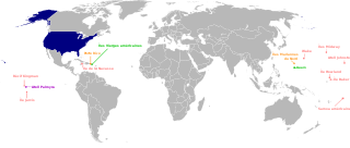
US insular areas - French map
Summary[edit]
| Description |
Français : Carte en français des différents territoires des Etats-Unis |
| Date | |
| Source |
This file was derived from: US insular areas.svg |
| Author | Mark Miller/Master of Time/Golbez ; derivative work : Skimel |
Licensing[edit]
This file is licensed under the Creative Commons Attribution-Share Alike 3.0 Unported license.
- You are free:
- to share – to copy, distribute and transmit the work
- to remix – to adapt the work
- Under the following conditions:
- attribution – You must give appropriate credit, provide a link to the license, and indicate if changes were made. You may do so in any reasonable manner, but not in any way that suggests the licensor endorses you or your use.
- share alike – If you remix, transform, or build upon the material, you must distribute your contributions under the same or compatible license as the original.
File history
Click on a date/time to view the file as it appeared at that time.
| Date/Time | Thumbnail | Dimensions | User | Comment | |
|---|---|---|---|---|---|
| current | 15:51, 24 March 2019 | | 1,474 × 628 (2.1 MB) | Skimel (talk | contribs) | User created page with UploadWizard |
You cannot overwrite this file.
File usage on Commons
There are no pages that use this file.
File usage on other wikis
The following other wikis use this file:
- Usage on fr.wikipedia.org
- Usage on nqo.wikipedia.org