File:US insular areas FAS.png

Original file (1,482 × 624 pixels, file size: 32 KB, MIME type: image/png)
Captions
Captions
Summary
[edit]
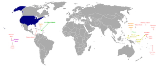
This is a map of the US Insular areas with the freely associated states of the Marshall Islands, Palau, and the Federated States of Micronesia (according to the US Office of Insular Affairs archive copy at the Wayback Machine, these islands are insular areas). The base map is Image:Dependent_territories_2007.png by User:Sesmith. This map is color coded according to each islands' status. Here is the key:
For an uncolor-coded map, see Image:US_insular_areas-B FAS.png. For a version without the freely associated states, see Image:US_insular_areas.png.
The previous map is PD; because of this, this map is too.
Licensing
[edit]
| I, the copyright holder of this work, release this work into the public domain. This applies worldwide. In some countries this may not be legally possible; if so: I grant anyone the right to use this work for any purpose, without any conditions, unless such conditions are required by law. |
File history
Click on a date/time to view the file as it appeared at that time.
| Date/Time | Thumbnail | Dimensions | User | Comment | |
|---|---|---|---|---|---|
| current | 05:00, 5 March 2008 | | 1,482 × 624 (32 KB) | Hoshie (talk | contribs) | == Summary == This is a map of the US Insular areas with the freely associated states of the Marshall Islands, Palau, and the Federated States of Micronesia (according to the [http://www.doi.gov/oia/Islandpages/political_types.htm US Office of Insular Af |
You cannot overwrite this file.
File usage on Commons
The following page uses this file:
File usage on other wikis
The following other wikis use this file:
- Usage on ckb.wikipedia.org
- Usage on en.wikipedia.org
- Usage on fa.wikipedia.org
- Usage on id.wikipedia.org
- Usage on mzn.wikipedia.org
- Usage on nl.wikipedia.org
- Usage on ru.wikipedia.org
- Usage on tg.wikipedia.org
- Usage on zh.wikipedia.org