File:UThantIsland.jpg
Jump to navigation
Jump to search

Size of this preview: 800 × 600 pixels. Other resolutions: 320 × 240 pixels | 640 × 480 pixels | 1,024 × 768 pixels | 1,280 × 960 pixels | 2,016 × 1,512 pixels.
Original file (2,016 × 1,512 pixels, file size: 854 KB, MIME type: image/jpeg)
Captions
Captions
Add a one-line explanation of what this file represents
Summary
[edit]
| Description |
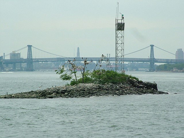
Deutsch: U Thant Insel, aufgenommen Juli 2005. English: en:U Thant Island, Taken July 2005. |
| Date | 3 August 2005 (original upload date) |
| Source | Transferred from en.wikipedia to Commons. |
| Author | Pacific Coast Highway at English Wikipedia |
| Openstreetmap entry | Link to Openstreetmap |
| Object location | | View this and other nearby images on: OpenStreetMap |
|---|
Licensing
[edit]
| This work has been released into the public domain by its author, Pacific Coast Highway at English Wikipedia. This applies worldwide. In some countries this may not be legally possible; if so: Pacific Coast Highway grants anyone the right to use this work for any purpose, without any conditions, unless such conditions are required by law. |
Original upload log
[edit]
The original description page was here. All following user names refer to en.wikipedia.
- 2005-08-03 21:19 Pacific Coast Highway 2016×1512×8 (874278 bytes) {{GDFL-user|Pacific Coast Highway}} [[U Thant Island]], Taken July 2005.
File history
Click on a date/time to view the file as it appeared at that time.
| Date/Time | Thumbnail | Dimensions | User | Comment | |
|---|---|---|---|---|---|
| current | 18:41, 12 August 2007 | | 2,016 × 1,512 (854 KB) | Adam~commonswiki (talk | contribs) | {{Information |Description=en:U Thant Island, Taken July 2005. |Source=Originally from [http://en.wikipedia.org en.wikipedia]; description page is/was [http://en.wikipedia.org/w/index.php?title=Image%3ACircle_Line_Photos_and_other_good_stuff%21_099.j |
You cannot overwrite this file.
File usage on Commons
The following page uses this file:
File usage on other wikis
The following other wikis use this file:
- Usage on bn.wikipedia.org
- Usage on de.wikipedia.org
- Usage on en.wikipedia.org
- Usage on es.wikipedia.org
- Usage on fi.wikipedia.org
- Usage on fr.wikipedia.org
- Usage on he.wikipedia.org
- Usage on hu.wikipedia.org
- Usage on ja.wikipedia.org
- Usage on ko.wikipedia.org
- Usage on la.wikipedia.org
- Usage on ms.wikipedia.org
- Usage on my.wikipedia.org
- Usage on pl.wikipedia.org
- Usage on vi.wikipedia.org
- Usage on www.wikidata.org