File:Uk-map.svg
Siirry navigaatioon
Siirry hakuun

Tämän PNG-esikatselun koko koskien SVG-tiedostoa: 271 × 599 kuvapistettä. Muut resoluutiot: 108 × 240 kuvapistettä | 217 × 480 kuvapistettä | 347 × 768 kuvapistettä | 463 × 1 024 kuvapistettä | 927 × 2 048 kuvapistettä | 1 021 × 2 255 kuvapistettä.
Alkuperäinen tiedosto (SVG-tiedosto; oletustarkkuus 1 021 × 2 255 kuvapistettä; tiedostokoko 204 KiB)
Kuvatekstit
Kuvatekstit
Lisää yhden rivin pituinen kuvaus tästä tiedostosta
Yhteenveto[muokkaa]
| Kuvaus |
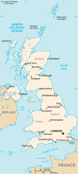
Vector version of CIA WorldBook map of the United Kingdom. Mercator projection. Vector information is from the CIA World DataBank II, and hence in the public domain. |
| Päiväys | 23. heinäkuuta 2006 (alkuperäinen tallennuspäivä) |
| Lähde | CIA World Factbook |
| Tekijä | CIA |
| Muut versiot |
|


Lisenssi[muokkaa]
Tämä teos on peräisin Yhdysvaltain keskustiedustelupalvelun (Central Intelligence Agency, CIA) julkaisemasta The World Factbookista. Teoksen on valmistanut jonkin Yhdysvaltain liittovaltion viranomaisen työntekijä osana kyseisen työntekijän virkatointa. Yhdysvaltain liittovaltion viranomaisten työntekijöiden tekemät teokset eivät saa tekijänoikeuden suojaa Yhdysvaltain tekijänoikeuslain 105 § mukaisesti.
|
 |
Tiedoston historia
Päiväystä napsauttamalla näet, millainen tiedosto oli kyseisellä hetkellä.
| Päiväys | Pienoiskuva | Koko | Käyttäjä | Kommentti | |
|---|---|---|---|---|---|
| nykyinen | 5. maaliskuuta 2024 kello 06.22 | | 1 021 × 2 255 (204 KiB) | Haziq Faruqi (keskustelu | muokkaukset) | File uploaded using svgtranslate tool (https://svgtranslate.toolforge.org/). Added translation for ms. |
| 6. marraskuuta 2023 kello 17.28 |  | 1 021 × 2 255 (185 KiB) | Belbury (keskustelu | muokkaukset) | Reverted to version as of 23:32, 23 July 2006 (UTC) better spacing before | |
| 18. huhtikuuta 2007 kello 13.43 |  | 1 021 × 2 255 (128 KiB) | Tene~commonswiki (keskustelu | muokkaukset) | Cleanup | |
| 23. heinäkuuta 2006 kello 23.32 |  | 1 021 × 2 255 (185 KiB) | Wereon (keskustelu | muokkaukset) | added scale | |
| 23. heinäkuuta 2006 kello 22.55 |  | 1 021 × 2 255 (189 KiB) | Wereon (keskustelu | muokkaukset) | Vector version of CIA WorldBook map of the United Kingdom. Vector information is from the CIA World DataBank II, and hence in the public domain. |
Et voi tallentaa uutta tiedostoa tämän tilalle.
Tiedoston käyttö
Seuraavat 7 sivua käyttävät tätä tiedostoa:
Tiedoston järjestelmänlaajuinen käyttö
Seuraavat muut wikit käyttävät tätä tiedostoa:
- Käyttö kohteessa ar.wikipedia.org
- Käyttö kohteessa arz.wikipedia.org
- Käyttö kohteessa be-tarask.wikipedia.org
- Käyttö kohteessa da.wikipedia.org
- Käyttö kohteessa de.wikipedia.org
- Käyttö kohteessa de.wikivoyage.org
- Käyttö kohteessa el.wikipedia.org
- Käyttö kohteessa en.wikipedia.org
- Geography of the United Kingdom
- Wikipedia:Recent additions 12
- List of United Kingdom locations
- List of United Kingdom locations: Boa-Bot
- List of United Kingdom locations: Ia-Im
- List of United Kingdom locations: J
- List of United Kingdom locations: Na-Nev
- List of United Kingdom locations: Q
- List of United Kingdom locations: V
- List of United Kingdom locations: X-Z
- List of United Kingdom locations: Bab-Bal
- List of United Kingdom locations: Peo-Pn
- List of United Kingdom locations: Bre-Bri
- List of United Kingdom locations: Bea-Bem
- List of United Kingdom locations: Bam-Bap
- List of United Kingdom locations: Bar
- List of United Kingdom locations: Bas-Baz
- List of United Kingdom locations: Aa-Ak
- List of United Kingdom locations: Al
- List of United Kingdom locations: Am-Ar
- List of United Kingdom locations: As-Az
- List of United Kingdom locations: Bou-Boz
- List of United Kingdom locations: Bur-Bz
- List of United Kingdom locations: Bru-Bun
- List of United Kingdom locations: Ca-Cap
- List of United Kingdom locations: Car-Cd
- List of United Kingdom locations: Chi-Ck
- List of United Kingdom locations: Com-Cor
- List of United Kingdom locations: Cl-Cn
- List of United Kingdom locations: Co-Col
- List of United Kingdom locations: Cos-Cou
- List of United Kingdom locations: Cre-Croc
- List of United Kingdom locations: Cru-Cu
- List of United Kingdom locations: Da-Dam
- List of United Kingdom locations: De-Dee
- List of United Kingdom locations: Eat-Ee
- List of United Kingdom locations: Ea-Eass
- List of United Kingdom locations: East A-East D
- List of United Kingdom locations: Do-Dor
- List of United Kingdom locations: Ds-Dz
- List of United Kingdom locations: Ef-El
- List of United Kingdom locations: Em-Ez
- List of United Kingdom locations: Fa-Fe
Näytä lisää tämän tiedoston järjestelmänlaajuista käyttöä.