File:Ukraine-Historical regions.svg
Jump to navigation
Jump to search

Size of this PNG preview of this SVG file: 700 × 480 pixels. Other resolutions: 320 × 219 pixels | 1,024 × 702 pixels | 1,280 × 878 pixels | 2,560 × 1,755 pixels.
Original file (SVG file, nominally 700 × 480 pixels, file size: 280 KB)
Captions
Captions
Add a one-line explanation of what this file represents
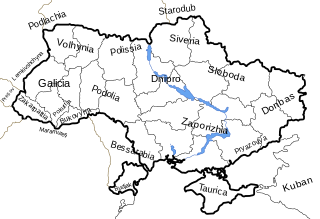
| Description | Map of Ukrainian historical regions and historical regions around Ukraine. |
| Date | |
| Source | Based off Image:Map of Ukraine political simple blank.svg map. |
| Author | Dima Sergiyenko; Please attribute this image as the work of "DiscoverWithDima." |
| Permission (Reusing this file) |
This file is licensed under the Creative Commons Attribution-Share Alike 4.0 International license. Attribution: DiscoverWithDima
|
File history
Click on a date/time to view the file as it appeared at that time.
| Date/Time | Thumbnail | Dimensions | User | Comment | |
|---|---|---|---|---|---|
| current | 06:34, 7 June 2007 | | 700 × 480 (280 KB) | Akhristov (talk | contribs) | Text fix |
| 21:28, 1 May 2007 |  | 700 × 480 (283 KB) | DDima (talk | contribs) | {{Information |Description=Map of Ukrainian historical regions and historical regions around Ukraine. |Source=Based off Image:Map of Ukraine political simple blank.svg map. |Date=May 1, 2007 |Author=DDima |Permission={{PD-user|DDima}} |
You cannot overwrite this file.
File usage on Commons
The following page uses this file:
- File:Ukraine-Historical regions .svg (file redirect)
File usage on other wikis
The following other wikis use this file:
- Usage on en.wikipedia.org
- Usage on fi.wikipedia.org
- Usage on fr.wikipedia.org
- Usage on uk.wikipedia.org
- Usage on zh.wikipedia.org