File:Ukraine-Historical regions.svg
跳转到导航
跳转到搜索

此SVG文件的PNG预览的大小:700 × 480像素。 其他分辨率:320 × 219像素 | 1,024 × 702像素 | 1,280 × 878像素 | 2,560 × 1,755像素。
原始文件 (SVG文件,尺寸为700 × 480像素,文件大小:280 KB)
说明
说明
添加一行文字以描述该文件所表现的内容
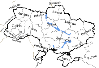
| 描述 | Map of Ukrainian historical regions and historical regions around Ukraine. |
| 日期 | |
| 来源 | Based off Image:Map of Ukraine political simple blank.svg map. |
| 作者 | Dima Sergiyenko; Please attribute this image as the work of "DiscoverWithDima." |
| 授权 (二次使用本文件) |
本文件采用知识共享署名-相同方式共享 4.0 国际许可协议授权。 署名: DiscoverWithDima
|
文件历史
点击某个日期/时间查看对应时刻的文件。
| 日期/时间 | 缩略图 | 大小 | 用户 | 备注 | |
|---|---|---|---|---|---|
| 当前 | 2007年6月7日 (四) 06:34 | | 700 × 480(280 KB) | Akhristov(留言 | 贡献) | Text fix |
| 2007年5月1日 (二) 21:28 |  | 700 × 480(283 KB) | DDima(留言 | 贡献) | {{Information |Description=Map of Ukrainian historical regions and historical regions around Ukraine. |Source=Based off Image:Map of Ukraine political simple blank.svg map. |Date=May 1, 2007 |Author=DDima |Permission={{PD-user|DDima}} |
您不可以覆盖此文件。
文件用途
以下页面使用本文件:
全域文件用途
以下其他wiki使用此文件:
- en.wikipedia.org上的用途
- fi.wikipedia.org上的用途
- fr.wikipedia.org上的用途
- uk.wikipedia.org上的用途
- zh.wikipedia.org上的用途