File:Ullene socken i Vilske härad.jpg
Jump to navigation
Jump to search
Size of this preview: 455 × 599 pixels. Other resolutions: 182 × 240 pixels | 605 × 797 pixels.
Original file (605 × 797 pixels, file size: 167 KB, MIME type: image/jpeg)
Captions
Captions
Add a one-line explanation of what this file represents
Summary
[edit]
| Description |
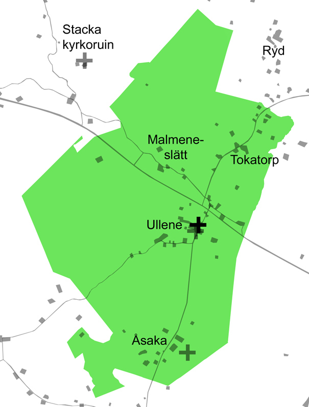
English: Map over Ullene parish in the Vilske hundred, municipality of Falköping, Västergötland, Sweden. Scale 1:40,000. The area of Ullene parish is marked green. The Ullene church is marked with a black cross. The grey crosses is marking church-ruins. Roads, farms and houses are grey.
Svenska: Karta över Ullene socken i Vilske härad, Falköpings kommun, Västergötland, Sverige. Skala 1:40.000. Ytan för Ullene socken markeras med grönt. Ullene kyrka är markerad med ett svart kors. De grå korsen visar ruinen efter Ullene gamla kyrka och Åsaka kyrkplats inom socknen, samt Stacka kyrkoruin i grannsocken Norra Vånga. Vägar och bebyggelse är markerade med gråtoner. Inom Ullene är Ullene kyrkby, Åsaka by, Malmeneslätt och Tokatorp namngivna. |
| Date | |
| Source | Own work |
| Author | Gunnar Creutz (Achird) |
Licensing
[edit]
| I, the copyright holder of this work, release this work into the public domain. This applies worldwide. In some countries this may not be legally possible; if so: I grant anyone the right to use this work for any purpose, without any conditions, unless such conditions are required by law. |
File history
Click on a date/time to view the file as it appeared at that time.
| Date/Time | Thumbnail | Dimensions | User | Comment | |
|---|---|---|---|---|---|
| current | 05:27, 18 June 2010 | | 605 × 797 (167 KB) | Achird (talk | contribs) | {{Information |Description={{en|1=Map over Ullene parish in the Vilske hundred, municipality of Falköping, Västergötland, Sweden. The area of Ullene parish is marked green. The Ullene church is marked with a black cross. The grey crosses is marking chu |
You cannot overwrite this file.
File usage on Commons
The following 2 pages use this file:
File usage on other wikis
The following other wikis use this file:
- Usage on sv.wikipedia.org
- Usage on www.wikidata.org