File:Union Plan Third Winchester.png
Jump to navigation
Jump to search
Size of this preview: 677 × 600 pixels. Other resolutions: 271 × 240 pixels | 542 × 480 pixels | 815 × 722 pixels.
Original file (815 × 722 pixels, file size: 903 KB, MIME type: image/png)
Captions
Captions
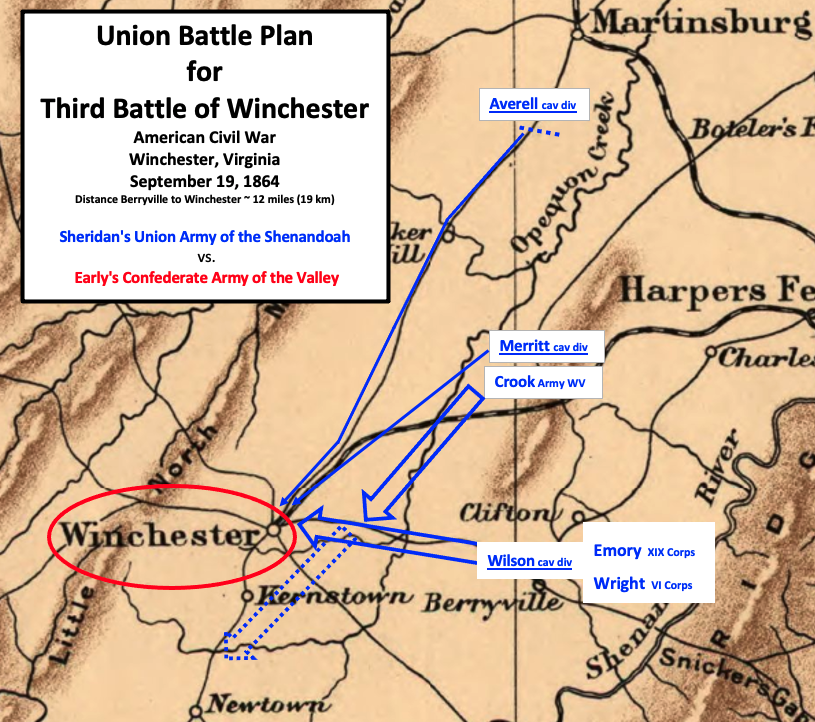
Sheridan planned to attack Early from multiple sides
Summary
[edit]
| Description |
English: This map outlines General Philip Sheridan's plan to attack Jubal Early's army at Winchester, Virginia during the American Civil War in September 1864. |
| Date | |
| Source | This is a portion of a 1912 map created by Sifton, Praed & Co. that has been modified by TwoScarsUp. The entire map can be found in the Library of Congress map, and shows Virginia and Maryland. Modifications are based on Sheridan's memoirs and Patchan's book "The Last Battle of Winchester: Phil Sheridan, Jubal Early, and the Shenandoah Valley Campaign, August 7-September 19, 1864". |
| Author | Sifton, Praed & Company, Ltd. modified by TwoScarsUp |
Licensing
[edit]
This work is in the public domain in the United States because it was published (or registered with the U.S. Copyright Office) before January 1, 1929.
Public domain works must be out of copyright in both the United States and in the source country of the work in order to be hosted on the Commons. If the work is not a U.S. work, the file must have an additional copyright tag indicating the copyright status in the source country.
Note: This tag should not be used for sound recordings. |
File history
Click on a date/time to view the file as it appeared at that time.
| Date/Time | Thumbnail | Dimensions | User | Comment | |
|---|---|---|---|---|---|
| current | 16:16, 19 November 2020 | | 815 × 722 (903 KB) | TwoScarsUp (talk | contribs) | Uploaded a work by Sifton, Praed & Company, Ltd. modified by TwoScarsUp from This is a portion of a 1912 map created by Sifton, Praed & Co. that has been modified by TwoScarsUp. The entire map can be found in the Library of Congress [https://www.loc.gov/item/99448878/ map], and shows Virginia and Maryland. Modifications are based on Sheridan's memoirs and Patchan's book "The Last Battle of Winchester: Phil Sheridan, Jubal Early, and the Shenandoah Valley Campaign, August 7-September 19, 1864... |
You cannot overwrite this file.
File usage on Commons
There are no pages that use this file.
File usage on other wikis
The following other wikis use this file:
- Usage on en.wikipedia.org