File:United States 1861-02-28-1861-03.png
跳转到导航
跳转到搜索
本预览的尺寸:800 × 542像素。 其他分辨率:320 × 217像素 | 640 × 433像素 | 1,000 × 677像素。
原始文件 (1,000 × 677像素,文件大小:113 KB,MIME类型:image/png)
说明
说明
添加一行文字以描述该文件所表现的内容
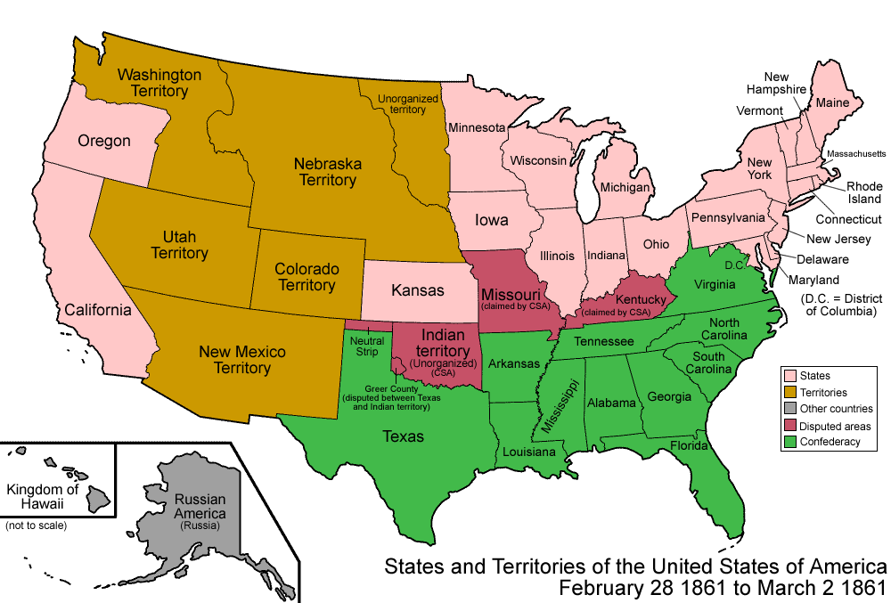
| 描述 | Map of the states and territories of the United States as it was from February 28 1861 to March 1861. On February 28, Colorado Territory was created from portions of Utah, New Mexico, Nebraska, and the previous Kansas Territories. On March 2 1861, Dakota Territory was split from Nebraska Territory, and gained the northern area of unorganized land; also, Nevada Territory was split from Utah Territory. |
| 来源 | 自己的作品 |
| 作者 | Made by User:Golbez. |
| 授权 (二次使用本文件) |
Own work, attribution required (Multi-license with GFDL and Creative Commons CC-BY 2.5) |
我,本作品著作权人,特此采用以下许可协议发表本作品:

|
已授权您依据自由软件基金会发行的无固定段落及封面封底文字(Invariant Sections, Front-Cover Texts, and Back-Cover Texts)的GNU自由文件许可协议1.2版或任意后续版本的条款,复制、传播和/或修改本文件。该协议的副本请见“GNU Free Documentation License”。 |
| 本文件采用知识共享署名-相同方式共享 3.0 未本地化版本许可协议授权。 | ||
| ||
| 本许可协议标签作为GFDL许可协议更新的组成部分被添加至本文件。 |
您可以选择您需要的许可协议。
| Territorial evolution maps of the United States |
| v · d (template shows date of beginning of change yyyy-mm-dd) |
| 1789-03, 1789-08, 1790-04, 1790-05, 1791-03, 1791-09, 1792-03, 1792-06, 1795, 1796, 1798, 1800-07-04, 1800-07, 1802, 1803-03, 1803-04, 1804-03, 1804-10, 1805-01, 1805-07, 1809, 1810-04, 1810-10, 1812-04, 1812-05, 1812-06, 1816, 1817-03, 1817-12, 1818-10, 1818-12, 1819-03, 1819-12, 1820, 1821-07, 1821, 1822, 1824, 1828, 1834, 1836-03, 1836-06, 1836-07, 1837-01, 1837-03, 1838, 1842, 1845-03, 1845-12, 1846-06, 1846-12, 1848-02, 1848-05, 1848-08, 1849, 1850, 1853-03, 1853-12, 1854, 1858, 1859, 1860, 1861-01, 1861-02-04, 1861-02-28, 1861-03, 1861-08, 1862, 1863-02, 1863-03, 1863-06, 1864-05, 1864-10, 1865, 1866, 1867-01, 1867-03, 1867-10, 1868, 1876, 1884, 1889-11-02, 1889-11-08, 1889-11-11, 1890-05, 1890-07-03, 1890-07-10, 1896-01, 1896-05, 1898, 1907, 1912-01, 1912-02, 1912-08, 1959-01, 1959-08 |
文件历史
点击某个日期/时间查看对应时刻的文件。
| 日期/时间 | 缩略图 | 大小 | 用户 | 备注 | |
|---|---|---|---|---|---|
| 当前 | 2006年7月29日 (六) 07:05 | | 1,000 × 677(113 KB) | Golbez(留言 | 贡献) | {{Information| |Description=Map of the states and territories of the United States as it was from |Source= |Date= |Author=Made by User:Golbez. |Permission=Own work, attribution required (Multi-license with GFDL and Creative Commons CC-BY 2.5) |other_ |
您不可以覆盖此文件。
文件用途
以下2个页面使用本文件:
全域文件用途
以下其他wiki使用此文件:
- de.wikipedia.org上的用途
- en.wikipedia.org上的用途
- User:Buaidh/Territorial evolution of Colorado
- List of territorial claims and designations in Colorado
- Territorial evolution of New Mexico
- Territorial evolution of Utah
- Territorial evolution of Arizona
- Talk:Territorial evolution of the United States/Archive 2
- List of Colorado-related lists
- List of trading posts in Colorado
- User:Falcaorib/Canada, United States and Mexico
- es.wikipedia.org上的用途
- fr.wikipedia.org上的用途
- ja.wikipedia.org上的用途
- vi.wikipedia.org上的用途
- zh.wikipedia.org上的用途