File:United States land claims and cessions 1782-1802.png
Naviqasiyaya keç
Axtarışa keç

Sınaq göstərişi ölçüsü: 573 × 600 piksel. Digər ölçülər: 229 × 240 piksel | 458 × 480 piksel | 747 × 782 piksel.
Faylın orijinalı (747 × 782 piksel, fayl həcmi: 145 KB, MIME növü: image/png)
Captions
Captions
Add a one-line explanation of what this file represents
Xülasə
[redaktə]| İzah |
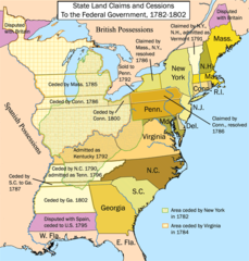
English: This is a map showing state land claims and cessions from 1782-1802 that I made. The disputed territory between New Hampshire and New York formed, in 1777, the independent country of 'New Connecticut' (later renamed 'Vermont') which eventually gained admission as the 14th state in 1791. Boundary disputes between states that were resolved before U.S. independence are not shown. |
| Tarix | 1782 - 1802 |
| Mənbə | Öz işi |
| Müəllif | Kmusser |
| Digər versiyalar |
|

Lisenziya
[redaktə]
I, the copyright holder of this work, hereby publish it under the following license:
This file is licensed under the Creative Commons Attribution-Share Alike 2.5 Generic license.
- Azadsınız:
- paylaşmaq – əsəri köçürmək, paylamaq və ötürmək üçün
- remiks etmək – əsəri adaptasiya etmək
- Aşağıdakı şərtlərə riayət etməklə:
- istinad – Müvafiq kredit verməlisiniz, lisenziyaya bir keçid verməlisiniz və dəyişikliklərin olub olmadığını bildirməlisiniz. Bunu hər hansı bir ağlabatan şəkildə edə bilərsiniz, ancaq lisenziyalaşdırıcının sizi və ya istifadənizi təsdiqləməsini təklif edən bir şəkildə deyil.
- bənzər paylaşma – Əsəri remix edirsinizsə, dəyişdirirsinizsə və ya üzərində iş aparırsınızsa, öz töhfələrinizi orijinalda olduğu kimi eyni və ya uyğun lisenziya altında yayımlamalısınız.

|
This historical map image could be re-created using vector graphics as an SVG file. This has several advantages; see Commons:Media for cleanup for more information. If an SVG form of this image is available, please upload it and afterwards replace this template with
{{vector version available|new image name}}.
It is recommended to name the SVG file “United States land claims and cessions 1782-1802.svg”—then the template Vector version available (or Vva) does not need the new image name parameter. |
Faylın tarixçəsi
Faylın əvvəlki versiyasını görmək üçün gün/tarix bölməsindəki tarixlərə klikləyin.
| Tarix/Vaxt | Miniatür | Ölçülər | İstifadəçi | Şərh | |
|---|---|---|---|---|---|
| hal-hazırkı | 17:12, 16 yanvar 2012 | | 747 × 782 (145 KB) | Ras67 (müzakirə | töhfələr) | cropped |
| 14:26, 28 sentyabr 2006 |  | 765 × 800 (154 KB) | Kmusser (müzakirə | töhfələr) | ||
| 14:12, 25 sentyabr 2006 |  | 765 × 800 (154 KB) | Kmusser (müzakirə | töhfələr) | ||
| 17:15, 21 sentyabr 2006 |  | 765 × 800 (155 KB) | Kmusser (müzakirə | töhfələr) | ||
| 21:46, 20 sentyabr 2006 |  | 765 × 800 (155 KB) | Kmusser (müzakirə | töhfələr) | ||
| 21:42, 20 sentyabr 2006 |  | 765 × 800 (495 KB) | Kmusser (müzakirə | töhfələr) | This is a map showing state land claims and cessions from 1782-1802 that I made. Boundary disputes between states that were resolved before independence are not shown. |
Siz bu faylı yenidən yükləyə bilməzsiniz.
Faylın istifadəsi
Aşağıdakı 3 səhifə bu faylı istifadə edir:
- Atlas of the United States
- File:Statecessions.png (fayl istiqamətləndirilir)
- File:USA Gebietsansprüche und -abtretungen 1782–1802.png
Faylın qlobal istifadəsi
Bu fayl aşağıdakı vikilərdə istifadə olunur:
- ar.wikipedia.org layihəsində istifadəsi
- az.wikipedia.org layihəsində istifadəsi
- bh.wikipedia.org layihəsində istifadəsi
- bn.wikipedia.org layihəsində istifadəsi
- ca.wikipedia.org layihəsində istifadəsi
- de.wikipedia.org layihəsində istifadəsi
- en.wikipedia.org layihəsində istifadəsi
- History of the United States
- Midwestern United States
- Treaty of Paris (1783)
- Northwest Territory
- U.S. territorial sovereignty
- Ohio Country
- Historical regions of the United States
- State cessions
- User:Kmusser/Images
- History of Michigan
- Portal:Michigan
- User:Notuncurious/Working/tmp3
- Confederation period
- User:Notuncurious/Working/tmp6
- Talk:List of capitals in the United States/Archive 1
- User:Drdpw/sandbox2
- User:AkeAcres87/sandbox
- User:Falcaorib/Canada, United States and Mexico
- es.wikipedia.org layihəsində istifadəsi
- fa.wikipedia.org layihəsində istifadəsi
- fr.wikipedia.org layihəsində istifadəsi
- he.wikipedia.org layihəsində istifadəsi
- hi.wikipedia.org layihəsində istifadəsi
- it.wikipedia.org layihəsində istifadəsi
- ja.wikipedia.org layihəsində istifadəsi
- ko.wikipedia.org layihəsində istifadəsi
- ms.wikipedia.org layihəsində istifadəsi
- nl.wikipedia.org layihəsində istifadəsi
- no.wikipedia.org layihəsində istifadəsi
- pt.wikipedia.org layihəsində istifadəsi
Bu faylın qlobal istifadəsinə baxın.
Kateqoriyalar:
- Maps of disputed territories in North America
- Territorial growth maps of the United States
- Northwest Territory
- English-language maps showing history
- 1780s maps of the United States
- 1790s maps of the United States
- Statehood of Vermont
- Statehood of Kentucky
- Statehood of Tennessee
- 1790s maps of Vermont
- Maps of the history of Vermont
- Maps of the history of Kentucky
- Maps of the history of Tennessee