File:United States land claims and cessions 1782-1802.png
跳至導覽
跳至搜尋

預覽大小:573 × 600 像素。 其他解析度:229 × 240 像素 | 458 × 480 像素 | 747 × 782 像素。
原始檔案 (747 × 782 像素,檔案大小:145 KB,MIME 類型:image/png)
說明
說明
添加單行說明來描述出檔案所代表的內容
摘要
[編輯]| 描述 |
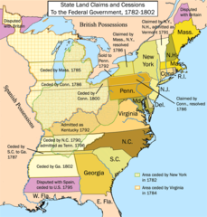
English: This is a map showing state land claims and cessions from 1782-1802 that I made. The disputed territory between New Hampshire and New York formed, in 1777, the independent country of 'New Connecticut' (later renamed 'Vermont') which eventually gained admission as the 14th state in 1791. Boundary disputes between states that were resolved before U.S. independence are not shown. |
| 日期 | 在1782年到1802年之間 |
| 來源 | 自己的作品 |
| 作者 | Kmusser |
| 其他版本 |
|

授權條款
[編輯]
我,本作品的著作權持有者,決定用以下授權條款發佈本作品:
此檔案採用創用CC 姓名標示-相同方式分享 2.5 通用版授權條款。
- 您可以自由:
- 分享 – 複製、發佈和傳播本作品
- 重新修改 – 創作演繹作品
- 惟需遵照下列條件:
- 姓名標示 – 您必須指名出正確的製作者,和提供授權條款的連結,以及表示是否有對內容上做出變更。您可以用任何合理的方式來行動,但不得以任何方式表明授權條款是對您許可或是由您所使用。
- 相同方式分享 – 如果您利用本素材進行再混合、轉換或創作,您必須基於如同原先的相同或兼容的條款,來分布您的貢獻成品。

|
本圖片是以PNG、GIF或JPEG格式上傳。然而,其中包含的資料或訊息,應該重新建立成可縮放向量圖形(SVG)檔案,以更有效率或更準確的方式儲存。如有可能,請上傳本圖片的SVG格式版本。在上傳之後,請修改維基各姊妹計畫中所有使用舊版圖片的條目(列在圖像連結章節中),替換為新版圖片,並在舊圖片的描述頁中加入{{Vector version available|新圖片名稱.svg}}模板,同時移除本模板。
|
檔案歷史
點選日期/時間以檢視該時間的檔案版本。
| 日期/時間 | 縮圖 | 尺寸 | 使用者 | 備註 | |
|---|---|---|---|---|---|
| 目前 | 2012年1月16日 (一) 17:12 | | 747 × 782(145 KB) | Ras67(留言 | 貢獻) | cropped |
| 2006年9月28日 (四) 14:26 |  | 765 × 800(154 KB) | Kmusser(留言 | 貢獻) | ||
| 2006年9月25日 (一) 14:12 |  | 765 × 800(154 KB) | Kmusser(留言 | 貢獻) | ||
| 2006年9月21日 (四) 17:15 |  | 765 × 800(155 KB) | Kmusser(留言 | 貢獻) | ||
| 2006年9月20日 (三) 21:46 |  | 765 × 800(155 KB) | Kmusser(留言 | 貢獻) | ||
| 2006年9月20日 (三) 21:42 |  | 765 × 800(495 KB) | Kmusser(留言 | 貢獻) | This is a map showing state land claims and cessions from 1782-1802 that I made. Boundary disputes between states that were resolved before independence are not shown. |
無法覆蓋此檔案。
檔案用途
下列3個頁面有用到此檔案:
全域檔案使用狀況
以下其他 wiki 使用了這個檔案:
- ar.wikipedia.org 的使用狀況
- az.wikipedia.org 的使用狀況
- bh.wikipedia.org 的使用狀況
- bn.wikipedia.org 的使用狀況
- ca.wikipedia.org 的使用狀況
- de.wikipedia.org 的使用狀況
- en.wikipedia.org 的使用狀況
- History of the United States
- Midwestern United States
- Treaty of Paris (1783)
- Northwest Territory
- U.S. territorial sovereignty
- Ohio Country
- Historical regions of the United States
- State cessions
- User:Kmusser/Images
- History of Michigan
- Portal:Michigan
- User:Notuncurious/Working/tmp3
- Confederation period
- User:Notuncurious/Working/tmp6
- Talk:List of capitals in the United States/Archive 1
- User:Drdpw/sandbox2
- User:AkeAcres87/sandbox
- User:Falcaorib/Canada, United States and Mexico
- es.wikipedia.org 的使用狀況
- fa.wikipedia.org 的使用狀況
- fr.wikipedia.org 的使用狀況
- he.wikipedia.org 的使用狀況
- hi.wikipedia.org 的使用狀況
- it.wikipedia.org 的使用狀況
- ja.wikipedia.org 的使用狀況
- ko.wikipedia.org 的使用狀況
- ms.wikipedia.org 的使用狀況
- nl.wikipedia.org 的使用狀況
- no.wikipedia.org 的使用狀況
- pt.wikipedia.org 的使用狀況
檢視此檔案的更多全域使用狀況。
分類:
- Maps of disputed territories in North America
- Territorial growth maps of the United States
- Northwest Territory
- English-language maps showing history
- 1780s maps of the United States
- 1790s maps of the United States
- Statehood of Vermont
- Statehood of Kentucky
- Statehood of Tennessee
- 1790s maps of Vermont
- Maps of the history of Vermont
- Maps of the history of Kentucky
- Maps of the history of Tennessee