File:Up to dateheid bestanden Aral meer voorbeeld.PNG
Jump to navigation
Jump to search
Size of this preview: 800 × 395 pixels. Other resolutions: 320 × 158 pixels | 824 × 407 pixels.
Original file (824 × 407 pixels, file size: 434 KB, MIME type: image/png)
Captions
Captions
Add a one-line explanation of what this file represents
Summary[edit]
| Description |
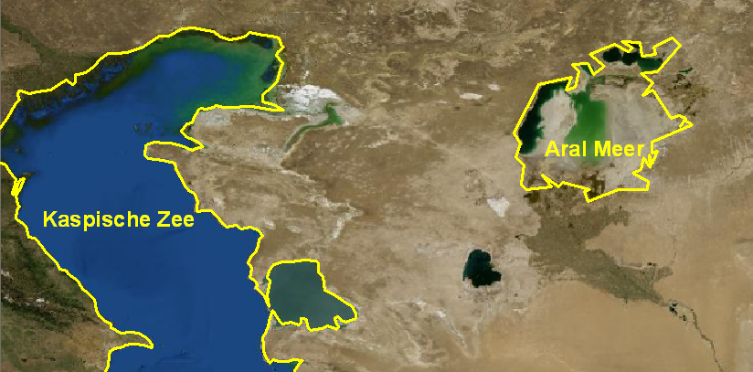
Nederlands: Figuur toont de vergankelijkheid van (sommige) geo-informatie. Grenzen van landen en - in dit geval - meren kunnen wijzigen. Voorbeeldfiguur. |
| Date | |
| Source | |
| Author | T.Nijeholt |
| Permission (Reusing this file) |
PD-USGov-NASA |
Licensing[edit]
| This file is in the public domain in the United States because it was solely created by NASA. NASA copyright policy states that "NASA material is not protected by copyright unless noted". (See Template:PD-USGov, NASA copyright policy page or JPL Image Use Policy.) | ||
 |
Warnings:
|
Original upload log[edit]
Transferred from nl.wikibooks to Commons by Romaine using CommonsHelper.
The original description page was here. All following user names refer to nl.wikibooks.
- 2008-03-03 20:27 Nijeholt 824×407× (444829 bytes) {{Information |Description=Figuur toont de vergankelijkheid van (sommige) geo-informatie. Grenzen van landen en - in dit geval - meren kunnen wijzigen. Voorbeeldfiguur. |Source=Eigen gemaakte media, o.b.v.: achtergrond satellietdata: http://trac.openlayer
File history
Click on a date/time to view the file as it appeared at that time.
| Date/Time | Thumbnail | Dimensions | User | Comment | |
|---|---|---|---|---|---|
| current | 00:52, 30 March 2010 | | 824 × 407 (434 KB) | File Upload Bot (Magnus Manske) (talk | contribs) | {{BotMoveToCommons|nl.wikibooks|year={{subst:CURRENTYEAR}}|month={{subst:CURRENTMONTHNAME}}|day={{subst:CURRENTDAY}}}} {{Information |Description={{nl|Figuur toont de vergankelijkheid van (sommige) geo-informatie. Grenzen van landen en - in dit geval - m |
You cannot overwrite this file.
File usage on Commons
There are no pages that use this file.
File usage on other wikis
The following other wikis use this file:
- Usage on nl.wikibooks.org