File:Usage of color photos acquired by Ingenuity helicopter in planning the future route of Perseverance rover along Artuby ridge.png

Original file (1,430 × 1,061 pixels, file size: 4.32 MB, MIME type: image/png)
Captions
Captions
Summary
[edit]| Description |
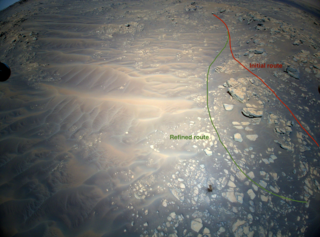
English: NASA’s Ingenuity Mars Helicopter acquired this image using its RTE (Return-to-Earth) 4208×3120 pixel, 47°×47° FOV color camera mounted at the bottom of its fuselage and pointed approximately 22° below the horizon. This image was acquired on August 16, 2021 (sol 174 of the Perseverance rover mission) at the local mean solar time of 13:25:08. This was the date of Ingenuity’s 12th flight.
Catalogue description This image sand dunes, boulders, and rocky outcrops of the "South Séítah" region of Mars' Jezero Crater was captured by NASA's Ingenuity Mars Helicopter during its 12th flight, on August 16, 2021. Ingenuity's shadow is visible in the lower third of the image, just right of center. A portion of the foot on one of the helicopter's four landing legs is visible along the upper-left edge of the image. In the upper-right corner (arching toward the top middle of the image) is a ridgeline that is of interest to the Perseverance rover science team. The Ingenuity Mars Helicopter was built by JPL, which also manages the operations demonstration activity during its extended mission for NASA Headquarters. It is supported by NASA's Science, Aeronautics Research, and Space Technology mission directorates. NASA's Ames Research Center in California's Silicon Valley, and NASA's Langley Research Center in Hampton, Virginia, provided significant flight performance analysis and technical assistance during Ingenuity's development. AeroVironment Inc., Qualcomm, and SolAero also provided design assistance and major vehicle components. Lockheed Martin Space designed and manufactured the Mars Helicopter Delivery System. |
| Date | 16 August 2021, 13:25:08 |
| Source | https://spectrum.ieee.org/media-library/aerial-image-of-a-hill-on-mars-showing-a-red-line-labeled-initial-route-going-over-the-hill-and-a-green-line-labeled-refined-route-going-around-the-hill.png?id=28138530 |
| Author | NASA/JPL-Caltech |
| Other versions |

Licensing
[edit]
| This file is in the public domain in the United States because it was solely created by NASA. NASA copyright policy states that "NASA material is not protected by copyright unless noted". (See Template:PD-USGov, NASA copyright policy page or JPL Image Use Policy.) | ||
 |
Warnings:
|
File history
Click on a date/time to view the file as it appeared at that time.
| Date/Time | Thumbnail | Dimensions | User | Comment | |
|---|---|---|---|---|---|
| current | 02:10, 19 December 2021 | | 1,430 × 1,061 (4.32 MB) | Cherurbino (talk | contribs) | Uploaded a work by NASA/JPL-Caltech; additional editing by IEEE Spectrum from https://spectrum.ieee.org/media-library/aerial-image-of-a-hill-on-mars-showing-a-red-line-labeled-initial-route-going-over-the-hill-and-a-green-line-labeled-refined-route-going-around-the-hill.png?id=28138530 with UploadWizard |
You cannot overwrite this file.
File usage on Commons
The following 2 pages use this file:
File usage on other wikis
The following other wikis use this file:
- Usage on ru.wikipedia.org